
- elevation 1,030 ft (314 m) Source Big Rock Ridge Road | - elevation 39 ft (12 m) | |
 | ||
- location 2 mi (3 km) east of Point Reyes Station | ||
Nicasio Creek is an 11.9-mile-long (19.2 km) stream in Marin County, California, United States which feeds into Lagunitas Creek. The Nicasio Reservoir, formed in 1961 by Seeger Dam, is located on this stream.
Contents
Map of Nicasio Creek, California, USA
CourseEdit
Originating on Big Rock Ridge west of the city of Novato, Nicasio Creek descends initially to the south. Approaching Lucas Valley Road, it turns and follows the road as it winds westward, passing south of Skywalker Ranch to the town of Nicasio. North of Nicasio, it feeds into Nicasio Reservoir just as Halleck Creek enters from the east. The reservoir drains to the west, through a gap in Bolinas Ridge. From the dam, Nicasio Creek parallels Point Reyes-Petaluma Road westward about 1 mile (1.6 km), then empties into Lagunitas Creek.
EcologyEdit
A river otter (Lontra canadensis) was collected by the Museum of Vertebrate Zoology at the southwest corner of Nicasio Reservoir in January, 2008.
BridgesEdit
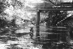
There are at least two bridges spanning Nicasio Creek. Point Reyes-Petaluma Road crosses the creek in two places: once 3.47 miles (5.58 km) east of State Route 1 on a 133-foot (41 m) concrete continuous tee beam constructed in 1960, and again 3.2 miles (5.1 km) east of State Route 1 on a 102-foot (31 m) concrete tee beam built in 1937.