
Easiest route rock/snow/ice climb Prominence 100 m Province Papua | Elevation 4,862 m First ascent 1936 Mountain range Sudirman Range | |
 | ||
Similar | ||
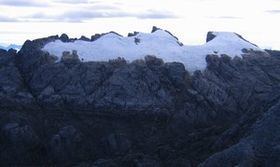
Ngga Pulu is a summit on the north rim of Mount Carstensz in the western part of the island of New Guinea rising 4862 meters (15,951 ft). Trigonometric measurements showed that Ngga Pulu was (and had been for many centuries before) the highest mountain of New Guinea and also the highest summit of the Australia/Oceania continent. The elevation of Ngga Pulu in 1936 was about 4907m (16,100ft), and it was the highest and most prominent peak between the Himalaya and the Andes. But due to glacial melting, Ngga Pulu lost a lot of elevation in the 20th century.
Contents
- Map of Ngga Pulu Tembagapura Mimika Regency Papua Indonesia
- Name
- Climbing history
- Loss of elevation and ice
- References
Map of Ngga Pulu, Tembagapura, Mimika Regency, Papua, Indonesia
Name
Ngga Pulu is the only summit of Mount Carstensz with a regular indigenous name. Sumantri and the current summit used to be called the NW and SE peaks of Ngga Pulu. Heinrich Harrer labeled the NW peak Ngapalu on his map drawn in 1962, while calling the SE Peak (the current Ngga Pulu) Sunday Peak. When Indonesia took control of Western New Guinea in 1963, the peaks were known as 'Puntjak Soekarno' and 'Puncak Jaya' until the Carstensz Pyramid was established as the highest summit. Sometimes after 1973 the NW summit was renamed to Sumantri, in honor of the recently deceased Minister of Energy and Mineral Resources.
Climbing history
Anton Colijn, Jean Jacques Dozy and Frits Wissel reached the summit on 5 December 1936 during the Carstensz Expedition over the Northwall Firn. Subsequent ascendants were Heinrich Harrer and company in 1962 and a Japanese-Indonesian expedition in 1964.[1]. Dick Isherwood first ascended the 600 m high north face in a solo effort in September 1972.
Loss of elevation and ice
The 1936 Carstensz Expedition measured a height of 5030 m for this summit. An Australian topographic survey in 1973 established that the 1936 barometric estimates were all between 117 and 125 m too high, suggesting a true height of 4907±10 m for Ngga Pulu in 1936. All prominence key cols in the inner Castensz area were entirely ice-covered, so the Carstensz Pyramid at the time was a just a sub-peak of Ngga Pulu, with around 200 m (656 ft) of prominence. The Australian scientific expeditions of 1971–73 measured Ngga Pulu at 4862m (15,951 ft), and the ice melting in the key col resulted in a prominence of around 300 m (1000 ft). By the year 2000, all New Guinea glaciers outside the Carstensz area had disappeared. Inside the Castensz area, a former sub-peak, the now rocky summit of Sumantri, is now some meters higher than the still ice-covered Ngga Pulu. So now, Ngga Pulu has less than 100 m (328 ft) of prominence as a sub-peak of the 4870 m (15,978 ft) Sumantri, which itself has a prominence around 350m (1149ft). The glacial melting has produced significant elevation changes for prominence key cols in the inner Carstensz area and it is also probable that other former big ice-capped peaks in New Guinea lost various meters in elevation such as Puncak Mandala, East Carstensz Top and Ngga Pilimsit. Scientists are monitoring this warming and estimate that by about 2020–30, all New Guinea glaciers may disappear.