
Time zone China Standard (UTC+8) | Area 304,683 km² | |
 | ||
Website Ngari(Ali) Prefecture Government Points of interest Mount Kailash, Lake Manasarovar, Tholing Monastery, Gurla Mandhata, Pangong Tso | ||
Ngari Prefecture (Tibetan: མངའ་རིས་ས་ཁུལ་, Wylie: mnga' ris sa khul; simplified Chinese: 阿里地区; traditional Chinese: 阿里地區; pinyin: Ālǐ Dìqū) is a prefecture of China's Tibet Autonomous Region. Its capital is Gar County. Its administrative centre is the town of Burang Town. The largest settlement is Shiquanhe. Ngari Prefecture includes part of the Aksai Chin area, a disputed region claimed by India but over which China exercises administrative control. The paved Xinjiang-Tibet Highway (新藏公路) passes through this area. There are well-known prehistoric petroglyphs near the far western town of Rutog.
Contents
Map of Ngari, Tibet, China
The town of Ngari lies 4,500 metres (14,800 ft) above sea level in northwest Tibet some 1,600 kilometres (990 mi) west of the capital, Lhasa. Ngari Gunsa Airport began operations on July 1, 2010, becoming the fourth civil airport on the "Roof of the World" (shortening the trip to Lhasa to one-and-a-half hours from three or four days by car). The other airports in Tibet are Lhasa Gonggar Airport in Lhasa, Qamdo Bamda Airport in Chamdo and Nyingchi Mainling Airport.
Ngari was once the heart of the ancient kingdom of Guge. Later Ngari, along with Ü and Tsang, composed Ü-Tsang, one of the traditional provinces of Tibet, the others being Amdo and Kham.
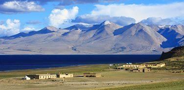
Ngari is best known for Mount Kailash, also called Sumeru, and Lake Manasarovar. Mount Kailash is 6,714 m (22,028 ft) above sea level and is the main peak of the Transhimalaya (also called the Kailash Range or Gangdisê Mountains). The holy mountain and lake are associated with a number of religions: Buddhism, Hinduism, and Bon, among others, attracting numerous domestic and international religious pilgrims and tourists. Surrounding Mount Kailash are four ancient and famous monasteries: Zhabura, Chiu Gompa, Zheri and Zhozhub. Manasarovar lies 4,588 m (15,052 ft) above sea level, covers an area of 412 km2 (159 sq mi) and reaches a maximum depth of 70 m (230 ft).
Subdivisions
Ali Prefecture is subdivided into seven county-level divisions: seven counties.