
Country India Languages spoken Malayalam, English | State Kerala Literacy 98.72% | |
Neyyattinkara [Standard and generally accepted abbreviations are NTA (used by general public) or NYY (used by Indian railway) of Neyyar River. This river flows from Agasthyarkoodam, the highest peak (1868m above MSL) in southern end of the Western Ghats.
Contents
- Map of Neyyattinkara
- History
- Geography
- Dubai kerala kitchen restaurant s food festival in jaihind tv
- References
Map of Neyyattinkara
The town comes under the surveillance of Neyyattinkara Municipality and it is the major town on the banks of Neyyar River. The rapidly growing Thiruvananthapuram city has almost reached its outskirts. The town is mostly residential, with lots of service sector establishments.
One of the most outstanding features of Neyyattinkara town is its transport service. There is 24 hours (in frequent intervals and as per the prescribed time schedule) to and fro bus service in NH 47 connecting Nagarcoil » Neyyattinkara » Trivandrum. Further, there is to and fro rail service connecting Nagarcoil » Neyyattinkara » Trivandrum.
Amaravila CSI church or C S I Amaravila founded in 1810 and known in those days as Emily Chapel, an oldest Church of Anglican Communion, is one of the main attractions of Neyyatiinkara Town.
Christ Nagar (Prayer Gardens is situated in Christ Nagar), Keerthy Nagar, Bapuji Lane, Mythry Nagar, New Street, Thozhukkal, Pallivilakom, Chembarathivila (Neyyattinkara sub-jail/prison is situated in Chembarathivila), Koottapana, Irumbil, Stuart Nagar, Thavaravila, Vadakkey Kotta (includes Krishnan Koil), T B Junction (this area is so close to the administrative building of Neyyattinkara Municipality, Neyyattinkara Fire and Rescue Service and Railway Station), Ooruttukala, Convent Road (St. Theresas HSS and Vidhyadhi Raja schools are situated in this road), Krishna Nagar, R C Street, Palakkadavu, Vlangamuri, Amaravila and Chaikkottukonam are the major residential areas in Neyyattinkara Municipal Limit.
Aruvippuram (7 km from Neyyattinkara town), the holy land of Sree Narayana Guru is an important pilgrim centre.
History
Cave pictures, probably by Neolithic people, are found in Pandavanpara, located in the North east side of Neyyattinkara towards Karakonam route. This famous cave will come under Perumkadavila panchayath. The name of this portion of land, before Marthanda Varma became the ruler of Travancore, was Thenganad.
The megaliths recently unearthed at Vizhinjam shows a splendorous display of craftsmanship that was prevalent in the region from the Middle Eras. Studies are going on to ascertain the ancient history of this region. Some of the historic relics of NTA are:
- Pandavan Para (believed to be having 5,000-year-old human inscriptions)
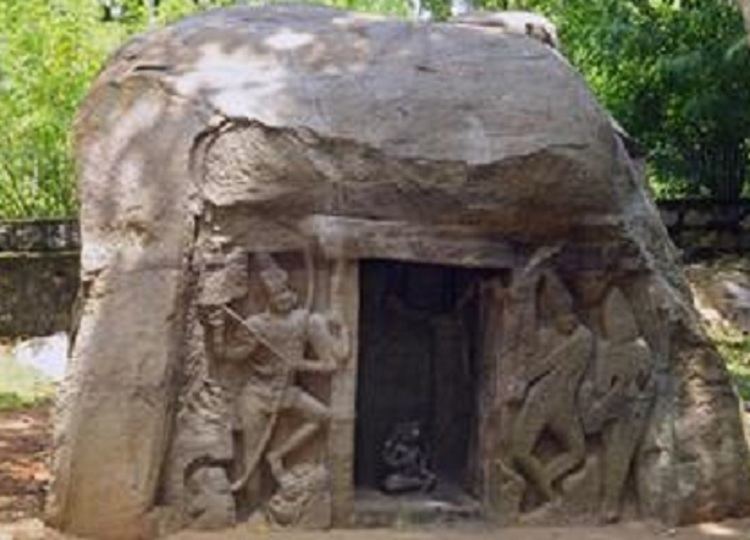
- Vizhinjam Cave Temple (constructed by the rulers of the Ay kingdom)
- Anantha Victoria Marthandan Canal (constructed during the British rule)
- Neyyattinkaras first library Njanapradayini
Geography
Neyyattinkara is located at 8.4°N 77.08°E? / 8.4; 77.08. It has an average elevation of 26 metres (85 feet). The town is situated on the Neyyar River side, one of the principal rivers in Trivandrum district. The river flows to the south part of the town. Water Supply for the town and the adjacent places is obtained from this river. Topography of the town is rather uneven, with higher areas in the downtown. Nearby the town is the hillock Aruvippuram. The Western Ghats form a scenic backdrop to the town. The town is sandwiched between the Western Ghats and the Arabian Sea. The nearby sea shore is just 10 km. away in west, and seven kilometres to the east can take you to the mammoth hillocks of Western ghats. The geology is said to be typical of the Kerala soil - the Laterite and Red soil. The town can still boast of a good green cover in residential and non-residential areas.