
CW end: SH 1 at Washdyke Length 457 km | ACW end: SH 1 at Clarksville | |
 | ||
Primary
destinations: Pleasant Point, Fairlie, Lake Tekapo, Twizel, Omarama, Cromwell, Clyde, Alexandra, Roxburgh, Lawrence Highway system New Zealand state highway network Major cities Lake Tekapo, Twizel, Omarama, Alexandra, Cromwell, Fairlie, Roxburgh, Lawrence, Washdyke, Clarksville | ||
State Highway 8 is one of New Zealand's eight national highways. It forms an anticlockwise loop through the southern scenic regions of the Mackenzie Basin and Central Otago, starting and terminating in junctions with State Highway 1. Distances are measured from north to south.
Contents
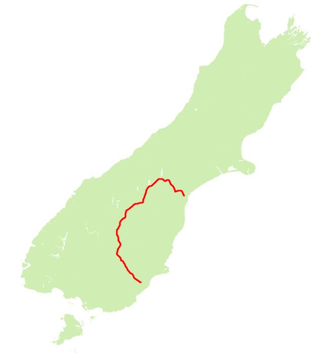
Map of State Highway 8, New Zealand
For most of its length SH8 is a two-lane single carriageway, with at-grade intersections and property accesses directly off the road, both in rural and urban areas.
Main route
The highway leaves SH1 at Washdyke, an industrial suburb of Timaru, travelling initially northwest towards the town of Fairlie. From here the route tends westward and rapidly increases in altitude, passing the southern end of the two great Mackenzie Basin lakes of Tekapo and Pukaki.
From Pukaki the highway turns southwest across the upper reaches of the Waitaki Valley, passing through the former hydroelectricity service town of Twizel and Omarama before again climbing to cross the Lindis Pass, which, at 971 metres, is the highest point on the highway's path. The highway winds along the valley of the Lindis River, reaching the upper Clutha River not far from Tarras.
From here, the highway runs close to the eastern shore of the man-made Lake Dunstan before passing the historic town of Cromwell. The highway turns south as it travels through the Cromwell Gorge passing the country's largest hydroelectric dam, the Clyde Dam at Clyde. The highway continues along the Clutha Valley through the town of Alexandra and past Lake Roxburgh to the town of Roxburgh. Much of this part of the highway's journey is past fruit orchards, and historic gold-diggings from the Central Otago Gold Rush.
From Roxburgh, the highway turns southeastward, passing Ettrick, Raes Junction and Beaumont, where it turns away from the Clutha, before reaching Lawrence, close to the original strike in the Central Otago Gold Rush. From here, the highway continues past Waitahuna and the twisting Manuka Gorge, reaching the plain of the Tokomairaro River at Clarksville, three kilometres south of Milton.
Highway spurs
State Highway 8 has two spurs: State Highway 8A and State Highway 8B. These two spurs connect the highway with State Highway 6, which lies on the western bank of Lake Dunstan. State Highway 8A runs for 23 km from SH6 at Luggate to connect with SH8 close to Tarras. State Highway 8B runs for just 2.6 km from SH8 at Deadmans Point across the lake to the town of Cromwell.
Route changes
The course of SH8 between Clyde and Tarras was substantially altered during the 1980s as part of the construction of the Clyde Dam, which flooded much of the Cromwell Gorge, including the former route of the highway. A completely new section was built between Clyde and Cromwell; for SH8B the old single-lane bridge crossing the Clutha was replaced with a new two-lane bridge approximately 1.5 km to the north.
Statistics
In 2006, SH8 had an annual average daily traffic volume (AADT - daily estimate) of between 1,188 vehicles at Bendigo, and 4,897 vehicles on the Clyde side of Alexandra. Over the eleven sites measured, between 9.0% and 15.3% of the vehicles were classified as heavy (3.5 tonnes or greater). For the spurs, SH8A AADT ranged from 646 to 858 vehicles, while the volume of vehicles on SH8B was 3,930 on Deadmans Point Bridge, and 4,500 near the SH6 junction.