
North end: SH 1 at Hamilton Length 500 km | South end: SH 2 at Woodville | |
 | ||
Primary
destinations: Te Awamutu, Otorohanga, Te Kuiti, New Plymouth, Hawera, Whanganui, Palmerston North Highway system New Zealand state highway network Major cities New Plymouth, Palmerston North, Whanganui, Hamilton, Te Kuiti, Otorohanga, Hawera, Te Awamutu, Woodville | ||
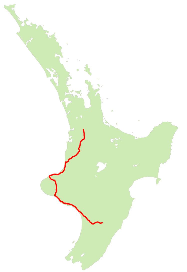
State Highway 3 (SH 3) is one of New Zealand's eight national state highways. It serves the west coast of the country's North Island and forms a link between State Highway 1 and State Highway 2. Distances are measured from north to south.
Contents
- Map of State Highway 3 New Zealand
- History
- Route
- Route changes
- Future improvements
- Spur sections
- References
Map of State Highway 3, New Zealand
For most of its length SH 3 is a two-lane single carriageway, with at-grade intersections and property accesses, both in rural and urban areas.
History
A Mokau - Awakino horse track was widened to a dray track about 1897. The first car to traverse the route from Auckland to New Plymouth seems to have been an 8 hp Cadillac in 1905, though Otorohanga to Te Kuiti was by train and, between Awakino and Mokau, a horse assisted on the beach. A 1910 Te Kuiti meeting called for metalling of the road to Awakino. Mt Messenger tunnel opened in 1916 and its single lane was enlarged about 1983. £3,000 (2016 equivalent $280,000) was provided in 1919 for the Awakino Gorge section, including the tunnel (enlarged in 2011), and it was opened in March 1923 at a total cost of about £60,000 (2016 equivalent $5.8m). Most of the route was gazetted as a government main highway in 1924, some sections were tar-sealed in 1925 and more work had been done on the road by 1936, leaving only a few mud sections. By 1949 the road was sealed as far south as Te Kuiti and the reinforced concrete bridge over the Waipa at Otorohanga had been started.
The 12 ft (3.7 m) wide, single-lane, 11-span, 670 ft (200 m), steel, Mokau Bridge opened in October 1927 (official opening 17 December), replacing a punt. The cost was £35,000 (2016 equivalent $3.3m). It had a lifting span allowing passage of vessels up to 50 ft (15 m) wide and with a 60 ft (18 m) clearance at high tide. In 2001 the 1927 bridge was replaced by the current 9-span, 230 m (250 yd), double lane, pre-stressed concrete bridge for $6.2m (2016 equivalent $8.5m). The new bridge doesn't allow for shipping, as the first ship to pass under the old lifting span was withdrawn three months after the bridge opened.
An 1871 account of a coach journey from New Plymouth to Wellington described the very poor road round the coast via Opunake to Whanganui and the much better and well used road south from there. A government subsidy of £3,000 (2016 equivalent $400,000) a year was being paid for the coach north of Whanganui.
Route
The highway leaves SH 1 at Hamilton, and initially heads south through farmland, passing through Te Awamutu. Sections of this stretch of the road are four-laned, but not divided carriageway. From Otorohanga it follows the valley of the Waipa River to Te Kuiti. The road then turns southwest through sparsely settled farmland, crossing several ridges before following the Awakino gorge to reach the coast, which it follows around the North Taranaki Bight. At the Tongaporutu River the highway turns inland to avoid coastal cliffs and climbs over Mount Messenger before descending via the Mimi River valley to return to the coast near Urenui. Bypassing Waitara, it reaches New Plymouth then turns inland, passing to the east of Mount Taranaki via Inglewood, Stratford and Eltham to Hawera.
From Hawera the highway follows the coast of the South Taranaki Bight southeastwards to Patea and Whanganui before meeting SH 1 again at Bulls. SH 1 and 3 share their route for 6 km as they cross the Rangitikei River to Sanson, where SH 3 continues southeast towards Palmerston North. After crossing the Manawatu River, the route follows its south bank through the Manawatu Gorge to its terminus and junction with SH 2 at Woodville in the Wairarapa.
Both the Awakino and Manawatu gorges are prone to closure by slips and rockslides in heavy rain.
Route changes
Construction of a bypass of Bell Block, a satellite town of New Plymouth, was completed in 2010. The bypass is a four-lane, divided expressway with an interchange at Henwood Road providing access to Bell Block.
In 2016, a section of SH 3 in Taranaki was realigned replacing the "deadly" Normanby overbridge.
Future improvements
On 27 January 2016, Prime Minister John Key announced funding for road bypasses of the two tunnels north of New Plymouth. Construction of the Mount Messenger and Awakino Gorge tunnel bypasses should begin within two years.
State Highway 3 will also form part of the future/proposed Southern Links motorway project in the South/West of Hamilton and Tamahere.
Other improvements include:
Spur sections
SH 3 has one spur, designated State Highway 3A. This 15.6 km stretch links State Highway 3 just west of Waitara to Inglewood, providing a shortcut and bypass of New Plymouth. The entire length of highway carries the name Mountain Road with the sole exception being a very short link of Rata Street in Inglewood to rejoin SH 3.