
Existed: c. 1931 – present Counties: Nassau Constructed 1931 | South end: NY 25A in Flower Hill Length 5.76 km County Nassau County, New York | |
 | ||
North end: Astor Lane in Sands Point | ||
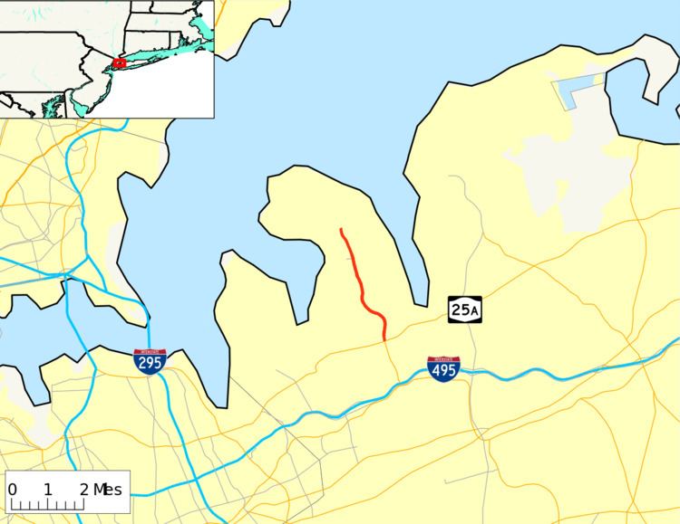
New York State Route 101 (NY 101) is a 3.58-mile (5.76 km) long state highway in northwestern Nassau County, New York, in the United States. It runs north–south as Port Washington Boulevard from NY 25A in Flower Hill, west of Roslyn and north of Manhasset, to Astor Lane in Sands Point. It continues south along Searingtown Road to Shelter Rock Road (County Route 8 or CR 8) and north on Middle Neck Road to a dead end at Long Island Sound as the unsigned County Route 101.
Contents
- Map of NY 101 North Hempstead NY USA
- Southern segment of CR 101
- NY 101
- Northern segment of CR 101
- History
- CR 101A
- Major intersections
- References
Map of NY-101, North Hempstead, NY, USA
NY 101 was assigned c. 1931 while the county route continuations were assigned in 1958. CR 101 was initially signed; however, signage for the route was removed in 1973. In the 1950s and 1960s, a proposal was made to construct a freeway in western Nassau County. The Western Nassau Expressway, as it was known, would have extended from NY 27 to NY 101 and utilized the NY 101 corridor north of NY 25A. The proposal was shelved in the 1970s.
Southern segment of CR 101
CR 101's southern segment begins at an intersection with Shelter Rock Road (CR 8) and Herricks Road near Herricks High School. The route heads eastward as Searingtown Road, passing to the south of the high school and to the north of a small pond. One block east of Herricks Road, CR 101 intersects with Old Searingtown Road, a former alignment of the current CR 101 alignment. At this point, the highway curves to the northeast and passes through a small area of trees nestled amongst a large, residential area bordering Williston Park. Old Searingtown Road rejoins CR 101 at the northern edge of the forested area.
The route continues north, serving as the boundary between Searingtown and Albertson as it proceeds past side streets lined by homes. At I.U. Willets Road, CR 101 serves Henry Wiscardi School and enters Searingtown. Just inside of the community, CR 101 intersects Hilldale Drive and Dogwood Road, two local streets connecting to Herricks Middle School. The route continues on through Searingtown into the village of North Hills, where the homes give way to trees as it turns to the northeast and passes under the Northern State Parkway. A short distance after the Northern Parkway overpass, CR 101 meets the Long Island Expressway (Interstate 495) by way of Nassau Boulevard—the southern service road—and North Service Road.
North of the Long Island Expressway, CR 101 passes by the Christopher Morley Park and Golf Course to the east and residential neighborhoods to the west. Past the park, CR 101 enters an area with more residential development as it begins to run along the western boundary of Roslyn Estates and the eastern edge of Manhasset. The homes give way to commercial developments as the highway approaches Flower Hill and NY 25A (Northern Boulevard). Searingtown Road becomes Port Washington Boulevard and CR 101 becomes NY 101 upon intersecting NY 25A.
NY 101
NY 101 continues north from NY 25A as a four-lane, undivided highway, passing homes, businesses and small patches of trees situated near the junction with NY 25A. At an intersection with Park Avenue North, NY 101 becomes a divided highway with two lanes in each direction. The highway continues north through Flower Hill to St. Francis Hospital, where it curves to the northwest to serve the center of Flower Hill. Here, NY 101 passes east of Flower Hill Park and west of North Hempstead Country Club before curving back to the north and entering Port Washington.
In Port Washington, NY 101 passes Nassau Knolls Cemetery and narrows to become a four-lane undivided highway as it enters the center of the hamlet. It proceeds north–south through downtown, passing several blocks of commercial buildings and Paul D. Schreiber Senior High School ahead of a junction with Main Street. North of this point, the surroundings of NY 101 become more residential as the route narrows to two lanes and passes into the village of Sands Point. NY 101 ends shortly afterward at an intersection with Astor Lane, at which point Port Washington Boulevard is continued by Middle Neck Road and designated as CR 101.
Northern segment of CR 101
The northern segment of CR 101 heads northward along Middle Neck Road, passing local residences and local commercial buildings to the west and the Village Club of Sands Point to the east. North of the club, the highway curves to the northwest and becomes surrounded by several blocks of residential homes to the southwest and patches of trees to the northeast as it heads deeper into the village.
From this point west to the highway's end on Long Island Sound, CR 101 follows a mostly east–west alignment through Sands Point. Along this last stretch, the route passes to the south of Sands Point County Park and north past Sands Point Golf Club as the surroundings around the route become increasingly forested and undeveloped. At Tibbits Lane, the route turns to the northwest and continues to the road's end at a dead end on the southern shore of Long Island Sound.
History
In the 1930 renumbering of state highways in New York, several of the routes assigned during the 1920s were renumbered or modified. At the same time, hundreds of state-maintained highways that did not yet have a route number were assigned one. One of these highways was Port Washington Boulevard, a roadway connecting NY 25A (Northern Boulevard) in Flower Hill to Astor Lane in Sands Point, which was designated as NY 101 by the following year. In 1959, the Nassau County Department of Public Works created a numbered highway system as part of their "Master Plan" for the county highway system. This plan marked CR 101 along its current alignment.
Since 2005, the traffic counts contained within the annual New York State Department of Transportation (NYSDOT) Traffic Data Report have indicated that the northern terminus of NY 101 is at an intersection with Beacon Hill Road. However, other documents produced by NYSDOT, such as their official description of routes in New York, give the highway's northern terminus as Astors [sic] Lane.
In 1952, the New York State Department of Public Works laid out plans for a six-lane expressway in western Nassau County. The proposed highway would begin at Atlantic Avenue in Freeport and head north to an intersection with NY 25A (Northern Boulevard) in Roslyn, and would've been designated NY-101. Local residents however opposed the plan, stating that the area was being developed too quickly. The proposed expressway was cancelled, and the $45 million that would have been used for the 11.5-mile (18.5 km) expressway went to extending the Meadowbrook State Parkway northward instead.
Although the original plan was shelved, the need for a highway in western Nassau County still existed. In 1963, the Department of Public Works revived the project; however, the routing was altered to extend from the Sunrise Highway (NY 27) north to an intersection with CR 101 (Middle Neck Road) in Sands Point. Part of the route would use modern NY 101 and the right-of-way of an abandoned Long Island Rail Road line. In 1971, several proposed crossings of the Long Island Sound were studied. One crossing, a bridge connecting Sands Point to New Rochelle to Westchester County, may have become a northward extension of the highway if it was constructed. By 1971, though, hopes had begun to fade on the highway's prospects of becoming reality. Even if construction had begun in that year, the highway would not be open to traffic until 1975. The project was eventually shelved.
CR 101A
CR 101A was a designation for the 0.5-mile (0.8 km) portion of Middle Neck Road between NY 25A and NY 101. The highway was a spur of CR 101 in name only as it never connected to CR 101.
Major intersections
The entire route is in Nassau County.