
OS grid reference SK08SE04 Post town STOCKPORT Dialling code 01663 | Sovereign state United Kingdom Postcode district SK23 6DZ | |
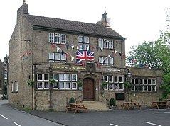 | ||
New Smithy is a hamlet in Derbyshire, England, near the village and in the parish of Chinley. It sits on the A624 trunk road from Glossop to Chapel-en-le-Frith featuring a TOTSO where left carries one down to Chapel and right heads to Chinley. There is a railway bridge over the turning, used for both freight and passengers, on the Hope Valley Line to Sheffield and Buxton; very close down the line is Chinley railway station. Next to this the Crown & Mitre pub is the main landmark and there are a couple of residential housing streets and terraces, and one or two businesses. The hamlet has an industrial past, along with the neighbouring village of Hayfield. New Smithy's Maynestone Mill was finally demolished in 1946, almost 500 years after it was opened in 1452.
Map of New Smithy, High Peak, UK
New Smithy is in a hilly area (being in the Peak District); geographical features include Bole Hill, Mount Famine, South Head, Eccles Pike, Mag Low, Chinley Churn, the River Sett and Combs Reservoir.