
Existed: June 1952 – present Length 15.6 km | Counties: Doña Ana Constructed June 1952 | |
 | ||
County | ||
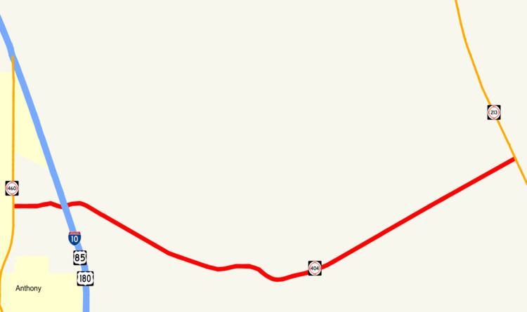
New Mexico State Road 404 is a paved, two-lane state-maintained road in Doña Ana County, New Mexico, U.S. that runs east–west across a gap between the northern edge of the Franklin Mountains and the southern edge of the North Franklin Mountains. The gap is known as the Anthony Gap due to its proximity to the community of Anthony, New Mexico.
Contents
Map of NM-404, New Mexico, USA
Running 9.7 mi (15.6 km), the east terminus of New Mexico State Road 404, or NM 404, is its intersection with NM 213 just west of Chaparral, New Mexico. The west terminus is in Anthony, New Mexico where it intersects with NM 460. It intersects Interstate 10.
Route description
The highway begins in Anthony at NM 460. 1 mile (1.6 km) later, the passes Interstate 10. NM 404 ends 8.7 miles (14.0 km) later at NM 213 after passing between the Franklin and North Franklin mountain ranges.
History
NM 404 was created in June 1952 by the New Mexico State Highway Commission as Anthony Gap Road. In December 1962, the State Highway Commission passed a resolution changing the road's name to Charles O'Hara Road, after a businessman from the Anthony area.
The original alignment is between NM 460 and NM 213. During the 1970s, the western terminus shifted westward to NM 478. In the 1980s, the western terminus moved further west to NM 28, but by the 2000s, the western terminus was at its original alignment. The former NM 404 highway between NM 28 and the Rio Grande is now NM 186.
Major intersections
The entire route is in Doña Ana County.