
Opened 1967 Total capacity 1.264 km³ Construction began 1964 | Opening date 1967 Height 149 m Surface area 28.92 km² | |
 | ||
Owner(s) Merced Irrigation District Type of dam Concrete–faced rockfill Similar Merced River, New Don Pedro Dam, Sierra Nevada, New Melones Dam, New Bullards Bar Dam | ||
New Exchequer Dam is a concrete–faced, rock-fill dam on the Merced River in central California in the United States. It forms Lake McClure, which impounds the river for irrigation and hydroelectric power production and has a capacity of more than 1,000,000 acre feet (1.2 km3). The Merced Irrigation District (MID) operates the dam and was also responsible for its construction.
Contents
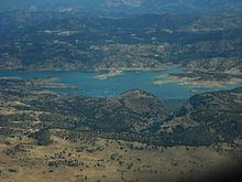
Map of New Exchequer Dam, Mariposa, CA 95338, USA
Built between 1964 and 1967, the dam replaced the old arch type Exchequer Dam and stands 490 feet (150 m) high. At the time of completion, it was the largest dam of its kind in the world. The dam is named for the town of Exchequer which now lies under the reservoir, while the reservoir is named for Wilbur F. McClure, the State Engineer of California during construction.
HistoryEdit
In 1926, after five years of planning and construction, MID completed the Exchequer or "Great Exchequer" Dam across the Merced River six miles (9.7 km) above the town of Merced Falls. The dam was a concrete gravity–arch structure 326 feet (99 m) high, holding a 14-mile (23 km) lake with a capacity of 281,000 acre feet (347,000,000 m3) of water. Although the dam was to serve primarily for irrigation, power production began ceremoniously on June 23, 1926 with a press of a telegraph key by President Calvin Coolidge, starting the turbines at a 31 megawatt hydroelectric plant.
By the 1950s, it became apparent that the limited storage capacity at Exchequer was no longer enough to serve the needs of farmers in the Merced River valley. A high dam was proposed to be built just downstream, creating a reservoir nearly four times the size of Exchequer.
Construction of New Exchequer Dam began on July 8, 1964, directly downstream from the old concrete arch dam. Tudor Engineering Company of San Francisco was responsible for the design of the new dam. The dam wall was constructed in vertical zones, which consisted of compacted, alternating layers of coarse and fine material ranging in thickness from 1.6 to 66 feet (0.49 to 20.12 m). The old Exchequer Dam was incorporated as an upstream toe to help support the rock-fill embankment, which was then armored with a layer of reinforced concrete. The dam was topped out in early 1967 and the power plant went into commercial operation by July.
As the new reservoir filled, it inundated an additional 15 miles (24 km) of the Merced River canyon and buried sections of the historic Yosemite Valley Railroad and the mining town of Bagby under 50 feet (15 m) of water. New Exchequer was among the first high concrete–faced rock-fill dams in the world, and its untested design resulted in significant leakage, sometimes up to 100 cubic feet per second (2.8 m3/s). MID began to repair the leaks in the fall of 1985 under orders from the California Division of Safety of Dams.
The dam has been able to halt major floods in many instances, such as the New Year's Day Flood of 1997. However, it has not always been able to weather the worst droughts – such as in 1977, when the reservoir fell to just 75,000 acre feet (0.093 km3), a fourteenth of capacity, and in 1991, which saw historic low water levels of 66,100 acre feet (0.0815 km3). In February 2015, the reservoir reached its lowest level on record, at 63,489 acre feet (0.078313 km3) or less than 7 percent of total capacity, due to three years of persistent drought.
Dimensions and usageEdit
New Exchequer Dam stands 490 feet (150 m) high from the foundations and 479 feet (146 m) above the Merced River. The dam is 1,220 feet (370 m) long, 18 feet (5.5 m) wide at the crest, 1,000 feet (300 m) wide at the base and is composed of 5,169,000 cubic yards (3,952,000 m3) of fill. High water releases are controlled by an ogee-type, gated overflow spillway located about 2 miles (3.2 km) north of the dam. The dam's power station has a capacity of 94.5 megawatts and generates about 316 million kilowatt hours annually.
The reservoir has a storage capacity of 1,024,600 acre feet (1.2638 km3), of which 350,000 acre feet (0.43 km3) is reserved for flood control. At full pool, the reservoir has an elevation of 867 feet (264 m), with 7,147 acres (2,892 ha) of water and 82 miles (132 km) of shoreline. To fulfill downstream flood control requirements, the reservoir will only be allowed to rise into the flood-control pool if the flow downstream at Stevinson is forecast to exceed 6,000 cubic feet per second (170 m3/s).
MID has proposed raising the spillway gates of the dam, which would provide up to 70,000 acre·ft (0.086 km3) of additional storage. However, this has met with controversy because it would result in part-time flooding of a portion of the Merced River designated Wild and Scenic. Opponents also point out that the raise is unnecessary, since the reservoir has never overflowed due to flooding since its completion in the mid-1960s.
Lake McClure is also extensively developed for recreational activities, with 515 campsites, four boat ramps and two marinas. In 1992, the lake received 606,000 visitor-days, mostly from May to September.