
1795–1807 → → Political subdivisions BialystokPlozk | 1806 914,610 Area 55,000 km² | |
 | ||
1806 55,000 km (21,236 sq mi) | ||
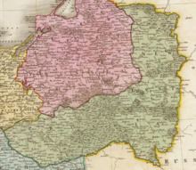
New East Prussia (German: Neuostpreußen; Polish: Prusy Nowowschodnie; Lithuanian: Naujieji Rytprūsiai) was a province of the Kingdom of Prussia from 1795 to 1807. It was created out of territory annexed in the Third Partition of Polish-Lithuanian Commonwealth and included parts of Masovia, Podlaskie, Trakai voivodeship and Žemaitija. In 1806 it had 914,610 inhabitants with a territory of less than 55,000 km².
Contents
Geography
New East Prussia encompassed territory between East Prussia and the Vistula, Bug River, and Neman rivers.
1807 Treaties of Tilsit
Following Napoleon Bonaparte's victory in the War of the Fourth Coalition and the Greater Poland Uprising of 1806 the Province of New East Prussia was ceded according to the 1807 Treaties of Tilsit:
Administrative divisions
New East Prussia was divided into the Kammerdepartements Bialystok and Plozk which were divided into the following counties (Kreise):