
Regional unit Arcadia Time zone EET (UTC+2) Elevation 700 m Area code 2710 | Postal code 220 05 Local time Friday 5:16 PM | |
 | ||
Weather 18°C, Wind E at 10 km/h, 30% Humidity | ||
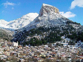
Nestani (Greek: Νεστάνη, before 1927: Τσιπιανά Tsipiana) is a village and a community in the municipal unit Mantineia, Arcadia, Greece. It is situated at the foot of the mountain Artemisio, at about 700 m elevation. It was the seat of the former municipality Mantineia. The community Nestani also contains the village of Milea. Nestani is 11 km east of Kapsas, 13 km southwest of Lyrkeia (Argolis) and 14 km northeast of Tripoli. The Moreas Motorway (Corinth - Tripoli) passes west of the village.
Contents
Map of Nestani 221 00, Greece
The monastery of Panagia Gorgoepikοos is situated on a hill immediately southeast of the village. The Holy Mother of God is venerated there, with a celebration on 15 August. The present building dates from 1740. It is now a nunnery.
History
Nestani was named after the ancient settlement Nestane, that was situated at the same place. Ancient Nestane was a village in the territory of the town Mantineia. Philip II of Macedon was said to have made his camp there. The ruined acropolis of Nestani and a spring named after Philip II can still be found near the present village.
The village of Tsipiana, which grew near the ancient ruins of Nestane, was renamed Nestani in 1927.