
Highest point Storevarden | Highest elevation 430 m (1,410 ft) Area 14.6 km² | |
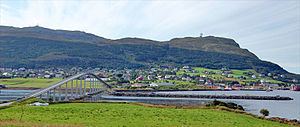 | ||
Nerlandsøya is an island in the municipality of Herøy in Møre og Romsdal county, Norway. The island is located northwest of the municipal center of Fosnavåg and east of the island of Skorpa. The island is connected to the island Bergsøya (to the southeast) by the Nerlandsøy Bridge. The Flåvær islands lie to the south. The highest point on the island is Storevarden which is 430 metres (1,410 ft) above sea level. The island has an area of 14.6 square kilometres (5.6 sq mi).
Map of Nerlands%C3%B8ya, 6098 Nerlands%C3%B8y, Norway
References
Nerlandsøya Wikipedia(Text) CC BY-SA