
Area rank 372 in Norway Area 119.8 km² Local time Friday 4:49 PM | Demonym(s) Herøyværing Population 8,847 (2013) | |
 | ||
Weather 4°C, Wind SW at 11 km/h, 86% Humidity Points of interest Geirangerfjord, Herøy Coastal Museum, Svinøy Lighthouse, Flåvær Lighthouse | ||
Herøy is a municipality in Møre og Romsdal county, Norway. It is part of the Sunnmøre region. The administrative centre is the town of Fosnavåg on the island of Bergsøya. The industrial area of Eggesbønes is located south of Fosnavåg on the same island. The Runde Environmental Centre is located in the northern part of the municipality on Runde island. Other population centres in Herøy include the villages of Leikong, Kvalsund, or Moltustranda.
Contents
Map of Her%C3%B8y, Norway
General information
The prestegjeld (parish) of Herøy was established as a municipality on 1 January 1838 (see formannskapsdistrikt). On 1 January 1867, the western district of Herøy was separated to become the new Sande Municipality. This left Herøy municipality with 1,999 residents. On 1 January 1873, an area of Sande (population: 362) was transferred back to Herøy. On 1 January 1889, the Eiksund area and Ekø island (population: 119) were transferred from Sande to Herøy.
On 1 January 1964, three farms in the Gurskedalen valley (population: 25) were transferred from Herøy to Sande. Also on that date, the Eiksund area and the Eika island (population: 222) were transferred from Herøy to neighboring Ulstein Municipality.
Name
The municipality (originally the parish) is named after an archipelago of small islands (Old Norse: Herøyjar). The first element is herr which means "army" (here in the sense skipaherr which means "military fleet") and the last element is the plural form of øy which means "island". Before 1918, the name was written Herø.
Coat-of-arms
The coat-of-arms is from modern times. They were granted in 1987. The arms show two stems which represent the 7th century Kvalsund boats found in the municipality.
Churches
The Church of Norway has three parishes (sokn) within the municipality of Herøy. It is part of the Søre Sunnmøre deanery in the Diocese of Møre.
Geography
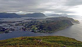
The main population and administrative centre of the municipality is the town of Fosnavåg, located on the island of Bergsøya. The municipality is entirely composed of islands located north of the Rovdefjorden. It includes the main islands of Bergsøya, Leinøya, Nerlandsøya, Remøya, Runde, Skorpa, Flåvær, and the eastern part of Gurskøya, plus many smaller islands. The island of Runde is especially notable for its large seabird colonies (and Runde Lighthouse), while Skorpa is famous for its role as a station for the Shetland bus. The islands are connected together via a series of bridges including the Runde Bridge, Remøy Bridge, Herøy Bridge, and Nerlandsøy Bridge.
The Herøyfjorden bisects Herøy municipality. The half located south of the fjord is referred to as Inner Herøy, while the half located north of the fjord is referred to as Outer Herøy. Inner and Outer Herøy are tied together by the Herøy Bridge which connects the islands of Gurskøy and Leinøya. Along this main route of traffic is the islet Notøy and the even smaller Herøya islet, an old trading station (now museum) and the original location of the original Herøy Church.
The fishing station Flåvær is located on a group of islets and skerries in the Herøyfjord, It includes the islets Flåvær, Husholmen, Torvholmen and Varholmen. The Flåvær Lighthouse is located on Varholmen.
The Svinøy Lighthouse is located on the very small island of Svinøy, about 12 kilometres (7.5 mi) west of the island of Skorpa.