
PIN 686693 Area code 0485 | Time zone IST (UTC+5:30) Telephone code 0485 Nearest city Kochi | |
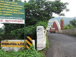 | ||
Neriamangalam the gateway to the high ranges of idukki
Neriamangalam is a village in Ernakulam district in the Indian state of Kerala. Neriamangalam is on the banks of Periyar River. It is on the border of Ernakulam and Idukki districts. Agriculture is the predominant occupation in this area. The Neriamangalam Bridge, Ranikallu (stone of queen) etc. are of historical importance. The Neriamangalam Bridge, built across the Periyar river, is often referred as 'The Gateway to the Highranges' as it is on the way to the higher regions of Idukki district, especially Munnar. The bridge was made by His Highness The Maharaja of Travancore in 1935. Now the bridge is a part of National Highway 49 which leads to Dhanushkodi in Tamil Nadu. The St Joseph's church, Neriamangalam is a major place of worship for Syro-Malabar Christians of this region. The Jawahar Navodaya Vidyalaya, Neriamangalam is an important educational institution in this region. Neriamangalam gets the highest average rainfall in the state of Kerala. So this place is aptly hailed as 'The Cherrapunjee of Kerala'. The nearest town is Kothamangalam, which is about 17.6 km (11 mi) from Neriamangalam.
Contents
- Neriamangalam the gateway to the high ranges of idukki
- Map of Neriamangalam Kerala 686693
- Demographics
- References
Map of Neriamangalam, Kerala 686693
Demographics
As of 2001 India census, Neriamangalam had a population of 16134 with 8145 males and 7989 females.