Kalpana Kalpana (Editor)

Neighborhoods in Washington, D.C.

Updated on
Edit
Like
Comment
Share on FacebookTweet on TwitterShare on LinkedInShare on Reddit
Neighborhoods in Washington, D.C.

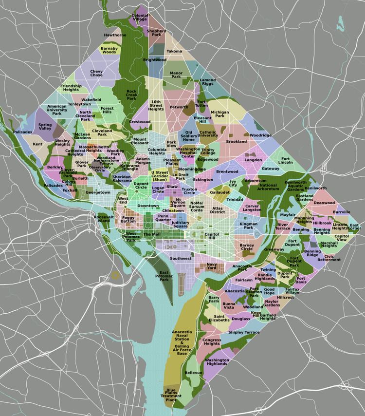
Neighborhoods in Washington, D.C. are distinguished by their history, culture, architecture, demographics, and geography. The names of 131 neighborhoods are unofficially defined by the D.C. Office of Planning. Neighborhoods can be defined by the boundaries of historic districts, Advisory Neighborhood Commissions, civic associations, and business improvement districts (BIDs); these boundaries will overlap.

Contents

Map of Washington, DC, USA

As the capital of the United States, Washington's local neighborhood history and culture is often presented as being distinct from that of the national government.

Ward 1

Ward 1 Councilmember: Brianne Nadeau Population (2010): 74,462
  • Adams Morgan
  • Columbia Heights
  • Howard University
  • Kalorama
  • LeDroit Park
  • Mount Pleasant
  • Park View
  • Pleasant Plains
  • Shaw (Part of the neighborhood are also in Ward 2 and Ward 6)
  • Ward 2

    Ward 2 Councilmember: Jack Evans Population (2010): 76,883
  • Burleith
  • Chinatown
  • Downtown
  • Dupont Circle
  • Federal Triangle
  • Foggy Bottom
  • Georgetown
  • Logan Circle
  • Mount Vernon Square (Part of the neighborhood is also in Ward 6)
  • Penn Quarter
  • Shaw (Parts of the neighborhood are also in Ward 1 and Ward 6)
  • Sheridan Kalorama
  • Southwest Federal Center
  • West End
  • Ward 3

    Ward 3 Councilmember: Mary Cheh Population (2010): 78,887
  • American University Park
  • Berkley
  • Cathedral Heights
  • Chevy Chase
  • Cleveland Park
  • Colony Hill
  • Forest Hills
  • Foxhall
  • Friendship Heights
  • Glover Park
  • Kent
  • Massachusetts Heights
  • McLean Gardens
  • North Cleveland Park
  • Observatory Circle
  • Potomac Heights
  • Spring Valley
  • Tenleytown
  • The Palisades
  • Wakefield
  • Wesley Heights
  • Woodland Normanstone
  • Woodley Park (Part of the neighborhood is also in Ward 1)
  • Ward 4

    Ward 4 Councilmember: Brandon Todd Population (2010): 75,773
  • Barnaby Woods
  • Brightwood
  • Brightwood Park
  • Chevy Chase (Part of the neighborhood is also in Ward 3)
  • Colonial Village
  • Crestwood
  • Fort Totten
  • Hawthorne
  • Manor Park
  • Petworth
  • Queens Chapel
  • Riggs Park
  • Shepherd Park
  • Sixteenth Street Heights
  • Takoma
  • Ward 5

    Ward 5 Councilmember: Kenyan McDuffie Population (2010): 74,308
  • Arboretum
  • Bloomingdale
  • Brentwood
  • Brookland
  • Carver Langston
  • Eckington
  • Edgewood
  • Fort Lincoln
  • Fort Totten
  • Gateway
  • Ivy City
  • Langdon
  • Michigan Park
  • North Michigan Park
  • Pleasant Hill
  • Riggs Park (Part of the neighborhood is also in Ward 4)
  • Stronghold
  • Trinidad
  • Truxton Circle
  • Woodridge
  • Ward 6

    Ward 6 Councilmember: Charles Allen Population (2010): 76,000
  • Barney Circle
  • Capitol Hill
  • Judiciary Square
  • Kingman Park
  • Mount Vernon Triangle
  • Navy Yard
  • Near Northeast
  • NoMa
  • Southwest Waterfront
  • Sursum Corda
  • Swampoodle
  • Ward 7

    Ward 7 Councilmember: Vince Gray Population (2010): 71,748
  • Benning Heights
  • Benning Ridge
  • Benning
  • Burrville
  • Capitol View
  • Central Northeast
  • Civic Betterment
  • Deanwood
  • Dupont Park
  • Eastland Gardens
  • Fairfax Village
  • Fairlawn
  • Fort Davis
  • Fort Dupont
  • Good Hope
  • Greenway
  • Hillbrook
  • Hillcrest
  • Kenilworth
  • Kingman Park
  • Lincoln Heights
  • Marshall Heights
  • Mayfair
  • Naylor Gardens
  • Penn Branch
  • Randle Highlands
  • River Terrace
  • Skyland
  • Twining
  • Ward 8

    Ward 8 Councilmember: Trayon White Population (2010): 73,662
  • Anacostia
  • Barry Farm
  • Bellevue
  • Buena Vista
  • Congress Heights
  • Douglass
  • Fairlawn
  • Garfield Heights
  • Knox Hill
  • Shipley Terrace
  • Washington Highlands
  • Woodland
  • References

    Neighborhoods in Washington, D.C. Wikipedia