
Country United States Ward Ward 5 Area 50 ha Population 4,980 (2010) | District Washington, D.C. Advisory Neighborhood Commission ANC 5E Zip code 20001 Area code 202 | |
 | ||
Restaurants Red Hen, Boundary Stone, Big Bear Cafe, The Pub & The People, The Old Engine 12 Restaurant | ||
Bloomingdale is a neighborhood in the Northwest quadrant of Washington, D.C., less than two miles (3 km) north of the United States Capitol building. It is a primarily residential neighborhood, with a small commercial center near the intersection of Rhode Island Avenue and First Street, NW featuring bars, restaurants, and food markets.
Contents
- Map of Bloomingdale Washington DC 20001 USA
- Geography
- Government
- History
- 1792 1870s farms and estates
- 1880s onward residential development
- Present
- Demographics
- Crispus Attucks Park
- Notable residents and historic landmarks
- In popular culture
- References
Map of Bloomingdale, Washington, DC 20001, USA
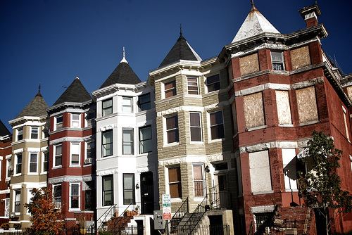
Most of Bloomingdale's houses are Victorian-style rowhouses built around 1900 as single-family homes. Today, they remain primarily single-family residences, with some recently converted to two-unit condominiums.
Geography
Bloomingdale is bounded to the north by Channing St., N.W., to the east by North Capitol St., to the south by Florida Ave., N.W., and to the west by Second St., N.W. The neighborhoods bordering Bloomingdale are LeDroit Park to the west, Shaw to the southwest, Truxton Circle to the south, Eckington to the east, and Stronghold to the northeast. To the north, sit the McMillan Sand Filtration Site and the McMillan Reservoir.
The neighborhood is a low-lying area, at the foot of hills that extend to the north and east. Its topography is also shaped by the now-buried Tiber Creek, one branch of which generally followed what is now Flagler Place NW.
Because of its low-lying topography, flooding periodically occurred in parts of the neighborhood during particularly strong rainstorms. In July 2012, the stormwater drainage system was overwhelmed three times by particularly strong storms, flooding vehicles near the topographic basin at T Street NW and Rhode Island Avenue NW and causing sewer backflow to enter some basements, many of which were rental apartments. Since then, DC Water has undertaken a large-scale tunneling project designed to divert and contain stormwater.
Government
Bloomingdale is in the southwestern part of Ward 5, currently represented on the City Council by Councilmember Kenyan McDuffie. Bloomingdale is a part of Advisory Neighborhood Commission 5E, currently represented by commissioners Teri Janine Quinn, Bertha Holliday, Horacio Sierra, and Dianne Barnes.
History
The present-day neighborhood of Bloomingdale originated from several large estates. Located just outside the original boundary of the City of Washington as designed by Pierre L’Enfant in 1792 and in the former County of Washington, the neighborhood known today as Bloomingdale began to develop its residential character in the late 1880s, shortly after the County of Washington was absorbed by the City of Washington and just over a century after L'Enfant's plan was developed.
1792-1870s: farms and estates
The lands that comprise Bloomingdale first began as large estates and orchards. Boundary Street, today Florida Avenue, was the dividing line between paved, planned streets (to the south), laid out in the original L'Enfant plan, and rural country (to the north of Boundary), where landowners maintained orchards, large country estates and, later, a mixture of commercial properties.
In 1823, George Beale and his wife Emily Truxton Beale bought a 10-acre (40,000 m2) parcel of land north of the Capitol, along the City boundary, for $600.00 from Wm Bradley. They named it the "Bloomingdale Estate," and it grew to 50 acres (200,000 m2).
As late as the 1870s, the land where Bloomingdale now sits was largely a collection of undeveloped private estates and farming properties, most prominently those of the Beales and of the Moores.
1880s onward: residential development
Following Emily Truxton Beale's death in 1885, her heirs began to sell large tracts of the estate to developers. The old Bloomingdale estate rapidly changed into the modern neighborhood configuration as developers and land speculators transformed the undeveloped lands for denser residential development, between the established residential LeDroit Park and Eckington neighborhoods. By 1887, city planners had proposed extending the city's paved street grid into Bloomingdale.
In 1891, the 45-acre (180,000 m2) Moore farm, north and west of the former Beale estate and representing some of the last undeveloped property in the area, was sold to private developers. It was incorporated into the already-underway Bloomingdale neighborhood.
By 1892, the reconfiguration of Bloomingdale was underway, as large estates were consolidated and reconfigured into the predecessor to the modern neighborhood, with further development by 1894. During this time, roads corresponding to the grid system of Washington's streets were improved, curbed, and paved. Streams and creeks were buried or re-directed — most notably the Tiber Creek, many of which had been buried south of Bloomingdale in the original City of Washington. One section of the Tiber Creek in Bloomingdale ran along what is now Flagler Place.
Construction on some of the earliest homes was completed between 1892 and 1900. In the early 1900s, the remainder of the surrounding blocks had been built in a speculative nature by such developers as Harry Wardman, Francis Blundon, and S. H. Meyers in the following decade. The neighborhood website contains a list of Bloomingdale's Wardman built homes. Many of Wardman's first homes incorporate elements of Richardson Romanesque architecture (a sub-category of Victorian). This can be seen in the ornate floral and vine-like stone carving around doors and windows of many Bloomingdale homes. His later homes, like those on Adams and Bryant Streets, are in an architectural style for which he is most prominently known, brick homes that incorporate a deeper setback from the street and large covered front porch. Blundon built several homes along 1st Street including 100 W Street, NW, which he occupied with his family.
Development continued and, in 1904, the neighborhood's first school, the Nathaniel Parker Gage School, was built on the 2000 block of 2nd Street. (The school has been converted to private condominiums.) By 1909, the old estates had been sold and divided, the Tiber Creek had been buried, and the neighborhood street layout had been fully developed into its present form.
Many homes in the northern section of Bloomingdale retain carriage houses in the block interiors. Some have been converted to private residences.
Present
Like many D.C. neighborhoods since the early 2000s, Bloomingdale has undergone substantial gentrification, with the neighborhood's once-numerous vacant properties being repurposed, sharp rises in property values, and rapidly shifting demographics. The population is primarily African American, which has maintained deep roots in the community for many years. There is a growing Hispanic and White population.
During this period of rapid change, new businesses have opened in the neighborhood, primarily restaurants, bars, and food markets. These include Windows Market, Big Bear Cafe, Yoga District, El Camino, Bacio Pizzeria, FieldToCity, Rustik Tavern, Boundary Stone, Aroi Thai Sushi Bar, Grassroots Gourmet, Red Hen, Showtime Lounge, and Crisp Kitchen & Bar. Every summer, the Bloomingdale Farmers' Market operates on Sundays on R St between Florida Ave and 1st Street, N.W.
On May 22, 2010, the city officially dedicated a new street, Bloomingdale Court, N.W., on the alleyway between the 100 block of U and V Streets, N.W., and the 2000 block of 1st Street and Flagler Place, N.W.
The neighborhood has several active neighborhood groups and associations including the Bloomingdale Civic Association.
Demographics
According to the 2010 census, the diverse population of Bloomingdale was 59% African American and 30% White with the last 11% split between Hispanic residents, Asian residents, and residents of other origins.
Crispus Attucks Park
Bloomingdale has its own community-managed and community-owned greenspace, Crispus Attucks Park. The acre-and-a-quarter park, in the court bounded by First, U, V, and North Capitol Streets N.W., was previously the site of a telephone switching station and cable yard for the Chesapeake & Potomac Telephone Company. In the late 1960s, the building and the site were left vacant until 1977, when a neighborhood organization that ultimately became the Crispus Attucks Development Corporation convinced Chesapeake & Potomac to sell the property.
The park is named after Crispus Attucks, an African American who was killed in the Boston Massacre and is often regarded as the first person killed in the American Revolution. Crispus Attucks Park is privately owned but open to the public. It is maintained through charitable donations and volunteer labor coordinated by the Crispus Attucks Development Corporation.
Notable residents and historic landmarks
In popular culture
Though the series is filmed in Baltimore, the opening credit sequence of House of Cards features several prominent shots of the Bloomingdale neighborhood along North Capitol Street, between R Street and T Street.