
Time zone EET (UTC+2) Vehicle registration Z Area code 210 | Elevation 430 m (1,410 ft) Postal code 152 xx Local time Thursday 6:44 AM | |
 | ||
Weather 12°C, Wind W at 5 km/h, 55% Humidity | ||
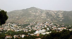
Nea Penteli (Greek: Νέα Πεντέλη) is a suburb in the northeastern part of the Athens agglomeration, Greece. Since the 2011 local government reform it is part of the municipality Penteli, of which it is a municipal unit.
Contents
Map of Nea Penteli 152 36, Greece
Geography
Nea Penteli is situated at the southwestern foot of the Penteli mountains, at 410 m (1,345.1 ft) elevation. The municipal unit has an area of 3.230 km2. It is 14 km (9 mi) northeast of Athens city centre. At the centre of the town is a small hill named Profitis Ilias, after the small church constructed on top of it. Nea Penteli has one primary school and a high school.
References
Nea Penteli Wikipedia(Text) CC BY-SA