
Location Peru Criteria i, iii, iv Inscription 1994 (18th Session) | Type Cultural Reference 700 | |
 | ||
UNESCO region Latin America and the Caribbean | ||
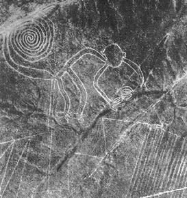
The Nazca Lines /ˈnæzkɑː/ are a series of large ancient geoglyphs in the Nazca Desert, in southern Peru. The largest figures are up to 1,200 ft (370 m) long. They were designated as a UNESCO World Heritage Site in 1994. The high, arid plateau stretches more than 80 km (50 mi) between the towns of Nazca and Palpa on the Pampas de Jumana, about 400 km south of Lima. Although some local geoglyphs resemble Paracas motifs, scholars believe the Nazca Lines were created by the Nazca culture between 500 BCE and 500 CE The figures vary in complexity. Hundreds are simple lines and geometric shapes; more than 70 are zoomorphic designs of animals, such as birds, fish, llamas, jaguars, and monkeys, or human figures. Other designs include phytomorphic shapes, such as trees and flowers.
Contents
The designs are shallow lines made in the ground by removing the reddish pebbles and uncovering the whitish/grayish ground beneath. Scholars differ in interpreting the purpose of the designs but, in general, they ascribe religious significance to them.
Because of its isolation and the dry, windless, stable climate of the plateau, the lines have mostly been naturally preserved. Extremely rare changes in weather may temporarily alter the general designs. As of 2012, the lines are said to have been deteriorating because of an influx of squatters inhabiting the lands.
Contrary to the popular belief that the lines and figures can be seen only with the aid of flight, they are visible from the surrounding foothills.
History
The first mention of the Nazca Lines in print was by Pedro Cieza de León in his book of 1553, where he mistook them for trail markers. Although partially visible from the nearby hills, the first to distinguish them were Peruvian military and civilian pilots. In 1927 the Peruvian archaeologist Toribio Mejía Xesspe spotted them while he was hiking through the foothills. He discussed them at a conference in Lima in 1939.
Paul Kosok, a historian from Long Island University, is credited as the first scholar to seriously study the Nazca Lines. In the country in 1940–41 to study ancient irrigation systems, he flew over the lines and realized one was in the shape of a bird. Another chance helped him see how lines converged at the winter solstice in the Southern Hemisphere. He began to study how the lines might have been created, as well as to try to determine their purpose. He was joined by Maria Reiche, a German mathematician and archaeologist, to help figure out the purpose of the Nazca Lines. They proposed one of the earliest reasons for the existence of the figures: to be markers on the horizon to show where the sun and other celestial bodies rose. Archaeologists, historians, and mathematicians have all tried to determine the purpose of the lines.
Determining how they were made has been easier than figuring why they were made. Scholars have theorized the Nazca people could have used simple tools and surveying equipment to construct the lines. Archaeological surveys have found wooden stakes in the ground at the end of some lines, which support this theory. One such stake was carbon-dated and was the basis for establishing the age of the design complex. Prominent skeptic Joe Nickell has reproduced the figures using tools and technology available to the Nazca people. Scientific American called his work "remarkable in its exactness" when compared to the actual lines. With careful planning and simple technologies, a small team of people could recreate even the largest figures within days, without any aerial assistance.
On the ground, most of the lines are formed by a shallow trench with a depth between 10 and 15 cm (4 and 6 in). Such trenches were made by removing the reddish-brown iron oxide-coated pebbles that cover the surface of the Nazca Desert. When this gravel is removed, the light-colored clay earth which is exposed in the bottom of the trench produces lines which contrast sharply in color and tone with the surrounding land surface. This sublayer contains high amounts of lime which, with the morning mist, hardens to form a protective layer that shields the lines from winds, thereby preventing erosion.
The Nazca "drew" several hundred simple but huge curvilinear animal and human figures by this technique. In total, the earthwork project is huge and complex: the area encompassing the lines is nearly 450 km2 (170 sq mi), and the largest figures can span nearly 1,200 ft (370 m). Some of the measurements for the figures conclude that the hummingbird is 93 m (310 ft) long, the condor is 134 m (440 ft), the monkey is 93 m (310 ft) by 58 m (190 ft), and the spider is 47 m (150 ft). The extremely dry, windless, and constant climate of the Nazca region has preserved the lines well. This desert is one of the driest on Earth and maintains a temperature around 25 °C all year round. The lack of wind has helped keep the lines uncovered and visible.
The discovery of two new small figures was announced in early 2011 by a Japanese team from Yamagata University. One of these resembles a human head and is dated to the early period of Nazca culture or earlier, and the other, undated, is an animal. In March 2012, the university announced a new research center would be opened at the site in September 2012 to study the area for the next 15 years. The team has been doing field work there since 2006 when it found about 100 new geoglyphs.
Purpose
Archaeologists, ethnologists, and anthropologists have studied the ancient Nazca culture to try to determine the purpose of the lines and figures. One hypothesis is that the Nazca people created them to be seen by their gods in the sky. Kosok and Reiche advanced a purpose related to astronomy and cosmology: the lines were intended to act as a kind of observatory, to point to the places on the distant horizon where the sun and other celestial bodies rose or set in the solstices. Many prehistoric indigenous cultures in the Americas and elsewhere constructed earthworks that combined such astronomical sighting with their religious cosmology, as did the later Mississippian culture at Cahokia in present-day United States. Another example is Stonehenge in England.
Gerald Hawkins and Anthony Aveni, experts in archaeoastronomy, concluded in 1990 that the evidence was insufficient to support such an astronomical explanation.
Reiche asserted that some or all of the figures represented constellations. By 1998, Phyllis B. Pitluga, a protégé of Reiche and senior astronomer at the Adler Planetarium in Chicago, had concluded that the animal figures were "representations of heavenly shapes". According to The New York Times, "she contends they are not shapes of constellations, but of what might be called counter constellations, the irregularly-shaped dark patches within the twinkling expanse of the Milky Way." Aveni criticized her work for failing to account for all the details.
In 1985, the archaeologist Johan Reinhard published archaeological, ethnographic, and historical data demonstrating that worship of mountains and other water sources predominated in Nazca religion and economy from ancient to recent times. He theorized that the lines and figures were part of religious practices involving the worship of deities associated with the availability of water, which directly related to the success and productivity of crops. He interpreted the lines as sacred paths leading to places where these deities could be worshiped. The figures were symbols representing animals and objects meant to invoke the gods' aid in supplying water. The precise meanings of many of the individual geoglyphs remained unknown as of 2013.
Henri Stierlin, a Swiss art historian specializing in Egypt and the Middle East, published a book in 1983 linking the Nazca Lines to the production of ancient textiles that archeologists have found wrapping mummies of the Paracas culture. He contended that the people may have used the lines and trapezes as giant, primitive looms to fabricate the extremely long strings and wide pieces of textiles typical of the area. According to his theory, the figurative patterns (smaller and less common) were meant only for ritualistic purposes. This theory is not widely accepted, although scholars have noted similarities in patterns between the textiles and the Nazca Lines, which they take as sharing in a common culture.
Alternative explanations
Other theories were that the geometric lines could indicate the flow of water, irrigation schemes, or be a part of rituals to "summon" water. The spiders, birds and plants may be fertility symbols. It has also been theorized that the lines could act as an astronomical calendar.
Phyllis Pitluga, senior astronomer at the Adler Planetarium and a protégé of Reiche, performed computer-aided studies of star alignments. She asserted the giant spider figure is an anamorphic diagram of the constellation Orion. She further suggested that three of the straight lines leading to the figure were used to track the changing declinations of the three stars of Orion's Belt. In a critique of her analysis, Dr. Anthony F. Aveni noted she did not account for the other 12 lines of the figure. He commented generally on her conclusions, saying:
I really had trouble finding good evidence to back up what she contended. Pitluga never laid out the criteria for selecting the lines she chose to measure, nor did she pay much attention to the archaeological data Clarkson and Silverman had unearthed. Her case did little justice to other information about the coastal cultures, save applying, with subtle contortions, Urton's representations of constellations from the highlands. As historian Jacquetta Hawkes might ask: was she getting the pampa she desired?
Jim Woodmann theorized that the Nazca lines could not have been made without some form of manned flight to see the figures properly. Based on his study of available technology, he suggests a hot-air balloon was the only possible means of flight. To test this hypothesis, Woodmann made a hot-air balloon using materials and techniques he understood to have been available to the Nazca people. The balloon flew, after a fashion. Most scholars have rejected Woodmann's thesis as ad hoc, because of the lack of any evidence of such balloons.
Environmental concerns
People trying to preserve the Nazca Lines are concerned about threats of pollution and erosion caused by deforestation in the region.
The Lines themselves are superficial, they are only 10 to 30 cm deep and could be washed away... Nazca has only ever received a small amount of rain. But now there are great changes to the weather all over the world. The Lines cannot resist heavy rain without being damaged.
– Viktoria Nikitzki of the Maria Reiche Centre
After flooding and mudslides in the area in mid-February 2007, Mario Olaechea Aquije, archaeological resident from Peru's National Institute of Culture, and a team of specialists surveyed the area. He said, "[T]he mudslides and heavy rains did not appear to have caused any significant damage to the Nazca Lines", but the nearby Southern Pan-American Highway did suffer damage, and "the damage done to the roads should serve as a reminder to just how fragile these figures are."
In 2013, machinery used in a limestone quarry was reported to have destroyed a small section of a line, and caused damage to another.
In December 2014, Greenpeace activists irreparably damaged the Nazca Lines while setting up a banner within the lines of one of the famed geoglyphs. The activists damaged an area around the hummingbird by grinding rocks into the sandy soil. Access to the area around the lines is strictly prohibited and special shoes must be worn to avoid damaging the UN World Heritage site. Greenpeace claimed the activists were "absolutely careful to protect the Nazca lines," but this is contradicted by video and photographs showing the activists wearing conventional shoes (i.e. not special protective shoes) while walking on the site. Greenpeace has apologized to the Peruvian people, but Loise Jamie Castillo, Peru's Vice Minister of Cultural Heritage, called the apology "a joke", because Greenpeace refused to identify the vandals or accept responsibility. Culture Minister Diana Alvarez-Calderon said that evidence gathered during an investigation by the government would be used as part of a legal suit against Greenpeace. "The damage done is irreparable and the apologies offered by the environmental group aren't enough," she said at a news conference. This also directed attention to other damage to geoglyphs outside of the World Heritage area caused in 2012 and 2013 by the Dakar Rally.