
Province Nazca Population 27,000 (2005) | Region Ica Elevation 520 m Local time Wednesday 9:54 PM | |
 | ||
Weather 24°C, Wind S at 10 km/h, 68% Humidity Neighborhoods Vista Alegre District, Nazca, Zone 3, Zone 1, Zone 5, Pampa de Chiquerillo, Zone 2, Zone 4 Points of interest Museo Arqueologico Antonini, Puquios, MUSEO MUNICIPAL, Los Paredones, Nazca Lines | ||
Nazca (/ˈnɑːskɑː, -kə/; sometimes spelled Nasca) is a city and system of valleys on the southern coast of Peru. It is also the name of the largest existing town in the Nazca Province. The name is derived from the Nazca culture that flourished in the area between 100 BC and 800 AD. This culture was responsible for the Nazca Lines and the ceremonial city of Cahuachi; they also constructed an impressive system of underground aqueducts, named Puquios, that still function today.
Contents
Map of Nazca, Peru
Nazca is the capital of the Nazca Province located in the Ica District of the Ica region of Peru.
Earthquake
On November 12, 1996, at 11:59 a.m. local time (16:59 GMT) there was an earthquake of magnitude 7.5 with its epicenter at 7.7 km into the sea. The earthquake almost completely destroyed the city of Nasca and its surroundings. Due to its occurrence during the day, there were only 14 fatalities. However, 1,500 people were injured and around 100,000 were left homeless. Within 12 years Nasca has been almost completely rebuilt.
Since 1997, Nazca has been the location of a major Canadian gold mining operation. The indigenous people at the time did not own the rights to their land. As a result, they were forcibly displaced. Since then, there have been several attempts to legalize ancient ownership of land and fixed property.
Climate
Nazca is one of the most arid regions in the world with an average annual precipitation of 4 millimeters. Nazca's weather is controlled by Humboldt's Current, which carries water from Antarctica up the west coast of South America.
This cold ocean water cools the air and limits the accumulation of moisture within clouds; as a result, though clouds and fog are able to form, there is little rain.
Nazca's temperatures range from 10 to 32 °C with an average daily high of 21 °C. Summer months from November to March are dry, sunny, and hot. During the winter from June to August, fog from the coast rolls over the hills to keep temperatures in the moderate range; however, the intense sun makes daylight hours seem hotter than they actually are.
History
There are two versions of the Spanish foundation. According to the writings of chroniclers, it was founded on October 28, 1548, commissioned by Pedro de la Gasca, peacemaker by Alonso de Mendoza. The other version states that it was founded by the Viceroy García Hurtado de Mendoza, 5th Marquis of Cañete, in 1591.
During the Spanish colonial period, Nazca was known for viticulture, producing wine and grape brandy (aguardiente de la uva), today commonly called pisco for the famous port of the same name - although, locally the brandy is known as Nasca. These products were widely distributed throughout the viceroyalty of Peru and beyond.
The largest of the Nazca vineyards were located in the rich Ingenio Valley, and were property of the Society of Jesus. The hacienda San Joseph de la Nasca, located in the upper part of the middle Ingenio Valley was owned by the Jesuit college of Cuzco, and San Francisco Xavier de la Nasca, in the lower part of the middle valley, was owned by the Jesuit College of San Pablo in Lima. Both of these estates had large enslaved populations of sub-Saharan African descent. In addition to producing wines and brandies, both estates had substantial infrastructure for producing the ceramic storage jars, known as botijas, in which the wine and brandy was transported. Today, the towns of San Javier and San José are known for the ruins of the large 18th-century baroque churches built during the Jesuit administration of these estates. In 1767, following the expulsion of the Society of Jesus by King Charles III of Spain, these properties became royal estates administrated by the Crown.
Nazca Patriots received the Liberating Expedition of General Don Jose de San Martin on October 14, 1820, after the Battle of Nasca escape. Two days earlier, on October 12, the General Juan Antonio Álvarez de Arenales, from Ica, was sent to the South in pursuit of the royal troops of Colonel Manuel Quimper fleeing from Ica, and having as its second and chief of staff of the Division de la Sierra, the Argentine Manuel Rojas Argerich Lieutenant Colonel in command of 250 men: 110 infantry and 140 cavalry.
The town of Nasca was established on August 29, 1821, and later on July 2, 1855, it was elevated to district and then it became a province on January 23, 1941.
Nasca, is as it is called today, has a dry climate, while in the time of the Incas, it was a formidable work of hydraulic engineering, water trayento Heights in underground branches, called aqueducts, which serve to the present, to irrigate farmland and for home use.
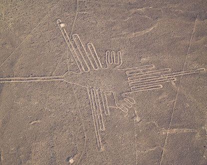
Nazca lines
The Nazca culture is famous for its desert line drawings. On the ground level, they cannot be discerned, but from a higher elevation, they can be seen forming coherent nature drawings, usually of animals. There are 12 figures in total (some as big as a football field). The UNESCO declared the Nazca Lines World Heritage in 1994.
Airport
Nazca has a small airport, the Maria Reiche Neuman Airport, used mainly for touristic flights over the Nazca lines.