
- elevation 196 m (643 ft) Length 201 km | - elevation 44 m (144 ft) | |
 | ||
- location | ||
Get busy fishin part 24 navasota river
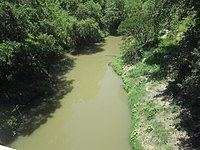
The Navasota River is a river in east Texas, USA. It is about 125 miles (201 km) long, beginning near Mount Calm and flowing south into the Brazos River at a point where Brazos, Grimes, and Washington counties converge.
Contents
- Get busy fishin part 24 navasota river
- Map of Navasota River Texas USA
- Get busy fishin part 14 navasota river
- Name
- Lakes
- References
Map of Navasota River, Texas, USA
Get busy fishin part 14 navasota river
Name
The river has been known by several names. The indigenous people called it the Nabasoto, Domingo Terán de los Ríos called it San Cypriano, Fray Isidro Félix de Espinosa called it the San Buenaventura, and in 1727, Pedro de Rivera y Villalón named it the Navasota.
Lakes
The Navasota River is dammed to form several lakes, including Lake Mexia, Springfield Lake, Joe Echols Lake, Lake Groesbeck, Lake Limestone, Martin Lake, and Lake Fort Parker in Fort Parker State Park.
References
Navasota River Wikipedia(Text) CC BY-SA