
- elevation 381 m (1,250 ft) - elevation 306 m (1,004 ft) Phone +351 255 381 209 | - elevation 1,280 m (4,199 ft) Area 72.2 km² Owner Portugal | |
 | ||
- location Serra de Alvão, Vila Marim, Vila Real - location Avenida António Macedo, Sé, Braga Address Lugar do Barrio, 4880-164, Portugal Geology Schist, Quartzite, Phyllite | ||
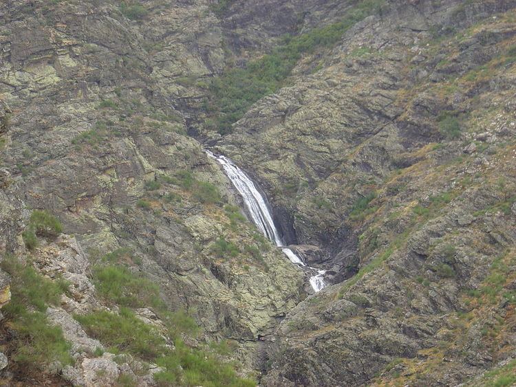
Vista para as cascatas das fisgas do ermelo parque natural do alv o
The Nature Park of Alvão (Portuguese: Parque Natural do Alvão) is a protected area founded in 1983, and located in the municipalities of Mondim de Basto and Vila Real, in the Tâmega and Douro Subregions of northern Portugal. Although the smallest of Portugal's nature parks, it extends through 72.2 square kilometres (27.9 sq mi) of mountainous land, populated by approximately 700 locals.
Contents
- Vista para as cascatas das fisgas do ermelo parque natural do alv o
- History
- Geography
- Physical geography
- Climate
- Biome
- Human geography
- References
History
The nature park was created on 8 June 1983 under terms of decree-law 237/83, as a classified nature park.
In order to support the conservation of nature, a resolution of the Council of Ministers (142/97), dated 28 August 1997, integrated Alvão into a broader area of classification under terms of the European Union's Natura 2000 designation: Sítio Alvão-Marão como (Sítio TCON0003 – Alvão-Marão). Under this arrangement community directives, such as those for bird species (79/409/CEE, 2 April) and habitats (92/43/CEE, 21 May) were included within the framework, in order to contribute to the conservation of habitats and species, their respective flora and fauna, considered under threat, within the European Union.
Geography
The Nature Park is located in the Trás-os-Montes and Alto Douro provinces, in the district Vila Real, divided between the municipalities of Vila Real (parishes of Borbela, Lamas de Olo and Vila Marim) and Mondim de Basto (parishes of Ermelo and Bilhó), occupying an area of 7220 hectares or 72.2 square kilometres (27.9 sq mi).
With an accidented topography, this Nature Park has a maximum vertical peak at Caravelas, 1,339 metres (4,393 ft) above sea level, and the lowest point in Lousa, along the Rio Olo, roughly 260 metres (850 ft) above sea level. There is a difference of approximately 1,079 metres (3,540 ft) points, permitting that allows a division of the park into two zones: a section that corresponds to the a great part of the parish of Lamas de Olo, that includes the elevated points along the Rio Olo watershed; and, a lower area represented by the parish of Ermelo, that includes Ribeira de Fervença and the Olo watershed, marked by the sudden drop associated with the Fisgas waterfall.
Physical geography
Much like a great part of the Transmontana region, PNAL is situated within the Maciço Antigo (Ancient Massif), within the Galiza-Trás-os-Montes subregion, a geomorphological unit constituted by eruptive and metamorphic rock formed by Hercynotype movements orienting the first groups along a northeast to southwest axis. Accompanying these movements were great expansions of granitic magma and prolonged secondary erosion, resulting in sedimentary cliffs and unaccented mountain ranges. A tertiary phase, in the raised areas, resulted in fractures in the dominant northeast-southwest axis, resulting in a variation in relief caused by different rock resistance.
The area is characterized by a dichotomous geological region, between schist and granite rock types.
Climate
The conditions of the park are defined by a temperate Atlantic climate, with Mediterranean characteristics. Within the headlands of the Olo River it is influenced by maritime air masses that rise over the limits of the park in the east. This situation results in heavy precipation during the winter months. These months are cold and rainy, with frequent snow showers in the high altitudes, while in the summer it is dry and warm. The major concentration of rain occurs in the colder months, while during the dry periods there is little rainfall, or concentrated in one month. The variation in slope allows for a diverse microclimate, with different vegetation between high and low altitudes. The combination of microcliamtic conditions and rainfall has resulted in a lush landscape.
Biome
Oak trees dominate the major elevated areas, especially along the banks of the river, along with species of Common hazel (Corylus avellana), holly (Ilex aquifolium), chestnut and laurel forming mixed forests, that include rare plants such as Sundew (Drosera rotundifolia), a species of carnivorous plants found in the moist lands along the riverfront.
The Olo River is rich in trout and is populated by the Eurasian otter (Lutra lutra).
Throughout the region, bird populations are diverse and include nesting pairs of Golden eagles. Mammal populations are marked by the presence of Wild boar (Sus scrofa), Roe deer (Capreolus capreolus), European badger (Meles meles), Granada hare (Lepus granatensis) and European rabbit (Oryctolagus cuniculus).
Among reptiles in the area are the Iberian emerald lizard (Lacerta schreiberi) and the Latastei viper (Vipera latastei).
Human geography
No less important to the region is the traditional architecture of the nature park region, especially in Ermelo and Lamas de Olo, defined as a distinct mountain style influenced by the sociological and artesanal nature of the landscape, or in Fervença, influenced by agrarian necessity along a terraced landscape.