
Area 103.4 km² Local time Tuesday 6:16 AM | Phone number 0246-25-5561 Population 976 (Oct 2016) Bird Japanese bush warbler | |
 | ||
Weather 6°C, Wind S at 18 km/h, 80% Humidity | ||
Naraha (楢葉町, Naraha-machi) is a town located in Futaba District, Fukushima Prefecture, Japan. As of December 2014, the town had an official registered population of 7,098 and a population density of 68.5 persons per km2, although the current actual resident population is much lower. The total area of the town is 103.45 square kilometres (39.94 sq mi). From 2011 until 2015, the town was evacuated due to fallout from the Fukushima Daiichi nuclear disaster. While the town wasn't severely contaminated by the fallout, restrictions on residency were held until September 2015 when cleanup efforts concluded, allowing people to return. Naraha is the first of several towns near Fukushima to have been reopened to residents.
Contents
- Map of Naraha Futaba District Fukushima Prefecture Japan
- Geography
- Surrounding municipalities
- History
- 2011 earthquake and tsunami
- Economy
- Education
- Railway
- Highway
- Local attractions
- International relations
- References
Map of Naraha, Futaba District, Fukushima Prefecture, Japan
Geography
Naraha is located in southern of Fukushima Prefecture, bordering on the Pacific Ocean to the east.
Surrounding municipalities
History
The area of present-day Naraha was part of Mutsu Province, and was included in the tenryo holdings of the Tokugawa shogunate during Edo period Japan. After the Meiji restoration, on April 1, 1889, the villages of Kido and Tatsuta was created within Naraha District, Fukushima. Naraha District became Futaba District in 1896. The villages of Kido and Tatsuta merged in 1956 to form the town of Naraha.
2011 earthquake and tsunami
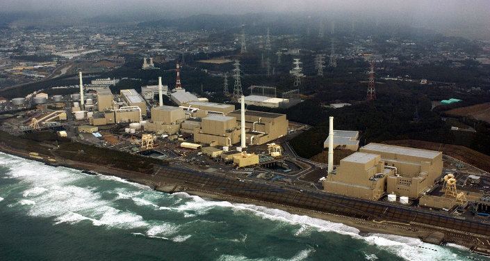
Naraha suffered great devastation as a result of the March 11 earthquake and subsequent tsunami. As a result of the Fukushima Daiichi nuclear disaster, as well as problems experienced with its cooling facility of the Fukushima Daini Nuclear Power Plant (see timeline), the town was totally evacuated by order of the town government. The entire area of the town fell within the 20 kilometer exclusion zone around the Fukushima Daiichi Power Plant. On August 1, 2012 the government eased the restriction order by allowing residents to visit their homes during daylight hours, but not permitting overnight stays. In March 2014, Naraha completed decontamination work in its residential areas, although radiation levels remained high in some areas of the town, and many buildings were still in ruins. By April 2015, residents could stay overnight if they applied for permission, and the evacuation order was lifted completely effective September 4, 2015. Reconstruction efforts have now begun as of 2016, with the town's citizens repairing damage caused by the Earthquake itself.
Economy
The economy of Naraha was formerly heavily dependent on agriculture. The Fukushima Daini Nuclear Power Plant was also a major employer.
Education
Naraha had one middle school and two elementary schools in March 2011.
Railway
Highway
Local attractions
Among other attractions, Naraha houses J-Village (currently disused), a state-of-the-art sports training and convention facility that also houses a hotel, restaurant and public bath. The Argentina National Football Team stayed at J-Village for the 2002 World Cup. Naraha also houses one of Japan's fifty-seven cycling terminals and an onsen.