
Country Norway District Namdalen Area rank 59 in Norway Area 1,417 km² Population 928 (2011) | County Nord-Trøndelag Administrative centre Namsskogan Demonym(s) Namsskoging Local time Monday 12:45 PM Official language form Norwegian Language | |
 | ||
Weather 0°C, Wind SE at 21 km/h, 63% Humidity | ||
Namsskogan is a village and municipality in Nord-Trøndelag, Norway. Namsskogan is located in the upper part of the long Namdalen valley region. The administrative centre of the municipality is the village of Namsskogan. Other villages in the municipality include Brekkvasselv, Smalåsen, Skorovatn, and Trones.
Contents
- Map of Namsskogan Norway
- General information
- Name
- Coat of arms
- Churches
- Politics
- Geography
- Government
- Municipal council
- References
Map of Namsskogan, Norway
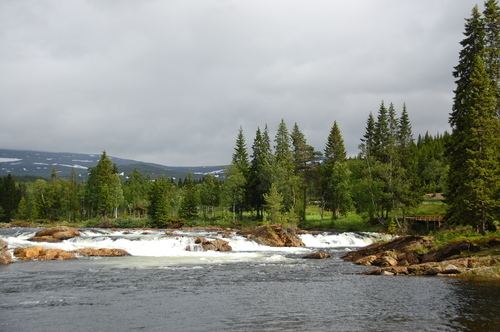
The village of Namsskogan lies along the river Namsen in the northern part of the municipality. The European route E6 highway runs through the village.
General information
The municipality of Namsskogan was established on 1 July 1923 when it was separated from the large municipality of Grong. Initially, the population of Namsskogan was 469. The municipal boundaries have not changed since.
Name
The name was created in 1923. The first element is the name of the river Namsen and the last element is the plural form of skog which means "wood". Therefore, the meaning of the name is "the woodlands around Namsen".
Coat-of-arms
The coat-of-arms is from modern times; they were granted on 21 December 1984. The arms show a gold moose's antler on a black background. The municipality is heavily forested and many moose can be found in the area. The arms are based on a very large antler, with a rare golden color, which hangs on the community hall.
See also: Coats-of-arms for Aremark, Namsos, Ringsaker, and TynsetChurches
The Church of Norway has one parish (sokn) within the municipality of Namsskogan. It is part of the Namdal deanery in the Diocese of Nidaros.
Politics
In the 2007 municipal elections, Namsskogan had the highest vote for the Socialist Left party in Norway, at 33.6 per cent.
Geography
Namsskogan is located in the northeast part of Nord-Trøndelag county. It is a heavily forested area with several large lakes including Kalvvatnet, Mellingsvatnet, Storfrøyningen, Storgåsvatnet, and Tunnsjøflyan. The river Namsen runs south through the Namsdalen valley. The extreme northeastern part of the municipality is part of Børgefjell National Park.
Government
All municipalities in Norway, including Namskogan, are responsible for primary education (through 10th grade), outpatient health services, senior citizen services, unemployment and other social services, zoning, economic development, and municipal roads. The municipality is governed by a municipal council of elected representatives, which in turn elect a mayor.
Municipal council
The municipal council (Kommunestyre) of Namskogan is made up of 13 representatives that are elected to every four years. Currently, the party breakdown is as follows: