
Time zone EAT (UTC+3) Area 7,510 km² | Formed 4 March 2013 Website nakuru.go.ke Population 1.603 million (2009) | |
 | ||
Colleges and Universities Egerton University, Kabarak University, Kenya Wildlife Service T, Nakuru Counseling & Trainin Points of interest | ||
Sixteen people killed in two separate accidents in nakuru county
Nakuru County is a county in Kenya. The capital and largest town is Nakuru, although Naivasha is another major significant urban centre. With a population of 1,603,325 (2009 census), it is the fourth largest county in Kenya after Nairobi, Kakamega and Kiambu in that order in terms of population. Nakuru County has an area of 2,325.8 km². Until 2013, it formed part of Rift Valley Province.
Contents
- Sixteen people killed in two separate accidents in nakuru county
- Map of Nakuru County Kenya
- Sites of Interest
- Urban Areas
- Urban Centres
- Nakuru County Peace Accord
- References
Map of Nakuru County, Kenya
Sites of Interest
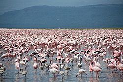
Nakuru County is home to Lake Nakuru and Lake Naivasha some of the Rift Valley soda lakes. Lake Nakuru is best known for its thousands, sometimes millions of flamingoes nesting along the shores. The surface of the shallow lake is often hardly recognisable due to the continually shifting mass of pink. The number of flamingoes on the lake varies with water and food conditions and the best vantage point is from Baboon cliff. Also of interest, an area of 188 km around the lake fenced off as a sanctuary to protect Rothschild giraffe and black rhinos.
Other sites of interest around Nakuru include Menengai Crater, an extinct volcano 2,490m (8,167 ft) high. The views of the crater itself, as well as the surrounding countryside, are spectacular.
Hyrax Hill Prehistoric Site, discovered by the Leakeys in 1926, is considered a major Neolithic and Iron Age site. The adjoining museum features finds from various nearby excavations.
The second largest surviving volcanic crater in the world, the Menengai Crater is 2,242 meters above sea level at its highest point. The crater plunges 483 m down from the rim and the summit is accessible by foot or vehicle 8 km from the main road. The mountain is also surrounded by a nature reserve.
RVIST is a tourist attraction.
Urban Areas
Surrounding towns include Lanet, which lies approximately 10 km from Nakuru is predominantly a residential town and is home to an army base. Njoro lies 20 km from Nakuru and is a small agricultural town with a local university aimed at promoting agricultural development in Kenya, namely Egerton University (est. 1934).
Urban Centres
* 2009 census. Source:
The county has Eleven constituencies:
Nakuru County was seen as the epicenter of violence in the aftermath of the disputed 2007 Presidential Elections which left over 1,100 people dead and over 350,000 displaced nationwide
Nakuru County Peace Accord
The Nakuru County Peace Accord (or “Rift Valley Peace Accord”) refers to the peace agreement signed on 19 August 2012 between elders of the Agikuyu (see also Kikuyu) and Kalenjin communities as well as other ethnic groups of Kenya.
The agreement was designed to address sources of ethnic conflict and a history of violence in the rift valley region of Kenya. It was signed following a 16 month-long peace process led by the National Cohesion and Integration Commission and the National Steering Committee on Peace Building and Conflict Management