
 | ||
Similar Uhuru Gardens, Taarifa Suites, Nairobi Animal Orphanage, Masinga Hydroelectric Power St, Karura Forest | ||
Nairobi dam now a health hazard
The Nairobi Dam is an embankment dam on the Nairobi River in Nairobi, Kenya.
Contents
- Nairobi dam now a health hazard
- Map of Nairobi Dam Nairobi Kenya
- Nairobi dam restoration by kiuesa
- Background
- Geology
- Regeneration projects
- References
Map of Nairobi Dam, Nairobi, Kenya
Nairobi dam restoration by kiuesa
Background
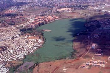
The Dam constructed in 1953 holds back a reservoir with storage capacity of 98,000 m3 (79 acre·ft) and surface area of 350,000 m2 (86 acres). It is a shallow lake with an average depth on only 2.76 m (9.1 ft)
Inflow is from the Motoine River, from rainfall, and waste water from the unsewered Kibera settlement. Outflow is through evaporation and over the spillway into the Ngong River.
The Dam is heavily silted and areas have been reclaimed for agrigulture by dumping solid waste.
The water hyacinth plant is very common and has clogged the water preventing sailing and fishing.
Geology
The sediment beneath the Dam consists of Middle and Upper Kerichwa Valley Tuffs.
Regeneration projects
Prime Minister Raila Odinga announced plans to regenerate the Dam and when he met with the Nairobi Dam Trust Initiative on 14 September 2011.
He asked that it be made part of the Nairobi River Basin Project funded by the United Nations Environment Program with the tasks of removing the water hyacinth and solid waste to restore the aquatic ecosystem. Also associated encroachment would need the settlements to be pulled down (Kibera is the second biggest slum in Africa, with 700,000 inhabitants) with an estimated cost of 700 million Kenyan Shilling (7.3 million USD)