
Topo map NTS 104G/07 Mountain type Cinder cone Prominence 45 m | Age of rock Holocene Elevation 1,690 m | |
 | ||
People also search for | ||
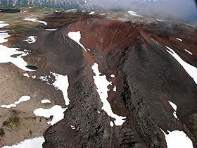
Nahta Cone is a cinder cone in northern British Columbia, Canada, located 69 km (43 mi) southwest of Tatogga, 9 km (6 mi) north of Wetalth Ridge and south of Telegraph Creek. It lies in the southwestern corner of Mount Edziza Provincial Park.
Contents
Map of Nahta Cone, Kitimat-Stikine D, BC, Canada
History
Nahta Cone was named on January 2, 1980 by the Geological Survey of Canada after the last seven survivors of the Wetalth people, a group outcast or exiled from the Tahltans in time past. Nahta is a Tahltan word meaning seven.
Geology
Nahta Cone is one of the youngest volcanic features in the Spectrum Range which in turn form part of the Mount Edziza-Spectrum Range volcanic complex and the Northern Cordilleran Volcanic Province. It formed in the Holocene period.
References
Nahta Cone Wikipedia(Text) CC BY-SA