
Location Freudenstadt Height (foundation) 35 m (115 ft) Impound Nagold | Construction began 1965–1970 Height 32.10 m (105.3 ft) Length 235 m (771 ft) | |
 | ||
Similar Nagold, Schwarzenbach Dam, Riesenrutschbahn Poppeltal ‑Seewald, Mummelsee, Schwarzwaldhochstraße | ||
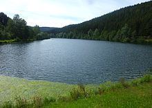
The Nagold Dam (German: Nagoldtalsperre, also Erzgrube) in the German state of Baden-Württemberg, was built between 1965 and 1970, and provides flood and drought protection in the Nagold valley. It lies within the county of Freudenstadt and was taken into service in 1971. The nearest settlement is Seewald-Erzgrube.
Contents
Map of Nagoldtalsperre, 72297 Seewald, Germany
LeisureEdit
Its location in the middle of a 650 hectare protected area in the Black Forest makes the impounded Nagold Reservoir a popular recreation area. From 1 April to 30 September, sailing is permitted on the lake. The dam has a pre-dam about 800 metres above the head of the reservoir.
LiteratureEdit
References
Nagold Dam Wikipedia(Text) CC BY-SA