
Country Philippines District 3rd District of Laguna Barangays Population 59,726 (2010) | Province Laguna Founded 1583 Elevation 229 m Local time Monday 8:40 AM | |
 | ||
Region CALABARZON (Region IV-A) Weather 26°C, Wind NE at 14 km/h, 67% Humidity Neighborhoods Manaol, Buhanginan, Alumbrado, Lawaguin, Abo Points of interest Nagcarlan Underground Cemetery, Villa Lorenza Resort, Glenda's Garden Resort, Mount Mabilog, Bunga Falls | ||
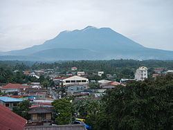
Nagcarlan is a second class municipality in the province of Laguna, Philippines. According to the 2010 census, it has a population of 59,726 people. It is 16 kilometres (9.9 mi) northeast of San Pablo City, or 103 kilometres (64 mi) south of Manila. Its coordinates are N14°07.93' E121°24.93' at 229.0 meters above sealevel.
Contents
- Map of Nagcarlan Laguna Philippines
- Tourism in Nagcarlan
- Barangays
- Notable people from Nagcarlan Laguna
- References
Map of Nagcarlan, Laguna, Philippines
Tourism in Nagcarlan
Nagcarlan has clean flowing rivers, gushing water falls, calm lakes and lush hills and mountains. Historic Spanish colonial sites, restaurants with competitive and affordable dishes, resorts and vacation house and a plethora of welcoming people.
Lack of promotion has caused this town to be overlooked by tourist and that is why locals have made their own ways to promote this town through blogging websites and conducting nature oriented activities like hiking and running.
Barangays
Nagcarlan is subdivided into 52 barangays.