
Country Philippines District 2nd District Time zone PST (UTC+8) Area 43.12 km² Province Ilocos Sur | Region Ilocos (Region I) Barangays ZIP code 2725 Local time Monday 8:39 AM | |
 | ||
Weather 27°C, Wind W at 2 km/h, 60% Humidity Neighborhoods Bantugo, Poblacion West, Balaweg | ||
Nagbukel municipal employees dance
Nagbukel is a fifth class municipality in the province of Ilocos Sur, Philippines. According to the 2015 census, it has a population of 5,259 people.
Contents
- Nagbukel municipal employees dance
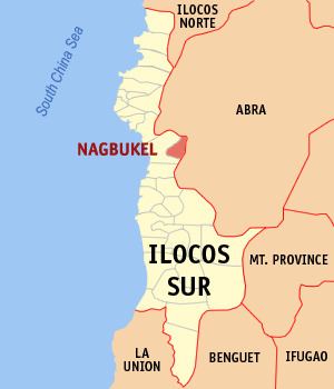
- Map of Nagbukel Ilocos Sur Philippines
- Miss nagbukel 2013 production number
- Barangays
- Etymology
- Demographics
- References
Map of Nagbukel, Ilocos Sur, Philippines
Miss nagbukel 2013 production number
Barangays
Nagbukel is politically subdivided into 12 barangays.
Etymology
The name of the municipality was thought to have come from the round shape of one of the hills in the area. People in the area would utter, "Anian nga nagbukel" (Ilocano meaning "How round it is.").
Another origin of the municipality's name comes from three small hills in the southern part of the municipality.
Another origin of the town's name comes from the irregular distribution of the barangays of Nagbukel and nearby Narvacan. Negotiations were made in such a way that the place east of the Kayapa River become part of Nagbukel and places west of the river become part of Narvacan. The distance from north to south was equal to the distance from east to west. The resulting area is round, hence the name "Nagbukel."
Demographics
In the 2015 census, the population of Nagbukel was 5,259 people, with a density of 120 inhabitants per square kilometre or 310 inhabitants per square mile.