Country Japan District Agatsuma - Flower Azalea Population 5,612 (Feb 2015) Bird Copper pheasant | Region Kantō - Tree Japanese Larch Area 133.8 km² Local time Monday 8:52 AM Prefecture Gunma Prefecture | |
 | ||
Time zone Japan Standard Time (UTC+9) Weather 4°C, Wind NW at 11 km/h, 69% Humidity Points of interest Kawarayuonsen Oyu, Uodomeno Falls, Fudo Falls, Hayashionsen Katakuri Hot Spring | ||
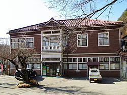
Naganohara (長野原町, Naganohara-machi) is a town located in Agatsuma District of western Gunma Prefecture in the northern Kantō region of Japan. As of February 2015, the town had an estimated population of 5,612 and a population density of 41.9 persons per km². Its total area was 133.85 km². The controversial Yanba Dam project is located within Naganohara.
Contents
- Map of Naganohara Agatsuma District Gunma Prefecture Japan
- Geography
- Surrounding municipalities
- History
- Economy
- Education
- Train
- Highway
- Local attractions
- References
Map of Naganohara, Agatsuma District, Gunma Prefecture, Japan
Geography
Located in the northwestern portion of Gunma Prefecture, almost all of Naganohara has an elevation higher than 500m. The town has Mount Kusatsu-Shirane (2171m) to the north and Mount Asama (2568m) to the south.
Surrounding municipalities
History
The area of present-day Naganohara has man remains from the Japanese Paleolithic through Jomon periods, although archaeological findings from the Kofun period are scarce compared with surrounding areas. During the Edo period, the area was part of the hatamoto-administered territory within Kōzuke Province.
Naganohara Town was created within Agatsuma District of Gunma Prefecture on April 1, 1889 with the creation of the municipalities system after the Meiji Restoration.
Economy
The economy of Naganohara is heavily dependent on agriculture.
