
Country Ukraine Raion Myronivka Raion City status 1968 Area 11.5 km² Local time Thursday 11:14 AM | Oblast Kiev Founded beginning 17th century Elevation 128 m (420 ft) Population 11,964 (2013) Team FC Nyva Myronivka | |
 | ||
Weather 9°C, Wind N at 11 km/h, 88% Humidity | ||
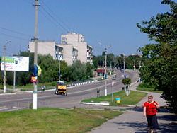
Mironovka is a city in Ukraine. It is located in the valley Rosava, in the region of Kyiv, 106 km from Kyiv.
Contents
Map of Myronivka, Kyivs'ka oblast, Ukraine
Geography
The city has area of 904 sq km. Ukraine's capital Kyiv is approximately 94 km from Myronivka (by air).
Prehistory
Near the city Bronze Age mounds were excavated. Nomads constructed eight mounds 10 to 12 inches high that contained skeletons of men and horses, iron hooks, stirrups and various decorations. On the outskirts were found pottery, bronze mirror Scythian and Greek vessels from around 6-4. BC., along with jewelry items from the 11th and 12th centuries, consisting of silver hryvnia, bracelets, chains and necklaces.
Modern era
The city was founded in the first half of the 17th century by Myron Green, who gave his name to the city.The surrounding villages were subjected to exploitation by Polish nobility; many disasters caused attacks by Tatars.