
Time zone BST (UTC+6) | Area 10,584 km² | |
 | ||
Points of interest Soshi Lodge, Alexander Castle, Botanical Garden, Hasan Monzil, Fish Museum & Biodiversi | ||
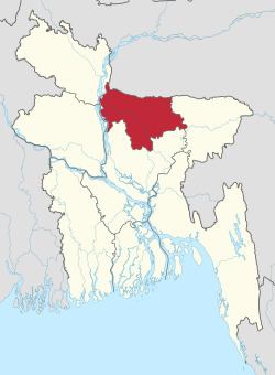
Mymensingh Division (Bengali: ময়মনসিংহ বিভাগ) is one of the eight administrative divisions of Bangladesh. It has an area of 10,485 km² and a population of 11,370,000 as of the 2011 census. It was created in 2015 from districts previously comprising the northern part of Dhaka Division. Its headquarters are in Mymensingh city in Mymensingh District.
Contents
- Map of Mymensingh Division Bangladesh
- Madhutila eco park sherpur mymensingh division
- History
- Administrative divisions
- References
Map of Mymensingh Division, Bangladesh
Madhutila eco park sherpur mymensingh division
History
The Greater Mymensingh region (Mymensingh District along with six other neighbouring districts) was created as a Mymensingh district by the British Indian government in 1787. Later, it was reorganized in two phases into six districts - Mymensingh, Kishoreganj, Netrakona, Tangail, Jamalpur, and Sherpur.
On 12 January 2015 prime minister Sheikh Hasina declared the establishment of a new Mymensingh Division. The intention was that this would carve six districts (those comprising the original Mymensingh district of 1787) out of the Dhaka Division. However, while four of the districts were eager about the establishment of new division, people of Tangail and Kishorgonj Districts wanted to remain part of Dhaka Division. On 14 September 2015 Mymensingh was officially announced as a division consisting four districts.
Administrative divisions
Census figures for 1991, 2001 and 2011 are from Bangladesh Bureau of Statistics, Population Census Wing. The 2011 Census figures are based on preliminary results.