
Country [[Pakistan
]] Time zone PST (UTC+5.30) | Headquarters Muzaffarabad Number of Tehsils 3 | |
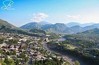 | ||
Muzaffarabad district (Urdu: ضِلع مُظفّر آباد), (Pahari: مُظفٌر آباد ضلع) of Kashmir, Pakistan is located on the banks of the Jhelum and the Neelum rivers, and is very hilly. The district is bounded to Punjab in the west and to Kupwara and Baramulla districts of the Kashmir in the east. To the north is Neelum District; the fall on the northeast of the district and Bagh District forms the southern boundary. The total area of the district is 6,117 square kilometres. The city of Muzaffarabad serves as capital of Kashmir.
Contents
Map of Muzaffarabad
It was part of Muzaffarabad Division.
Language and demography
Pahari, Potohari, Majhi, Chhachi and Gojri dialects of Punjabi Language and Kashmiri language are the predominant languages of the district. Other languages spoken include Urdu, Shina and Balti. The total population of the district according to the 1998 census was 725,000 and according to the 1999 projection its population stands at 741,000.
Administrative divisions
The district of Muzaffarabad is administratively subdivided into three tehsils, which are sub-divided into 51 Union Councils
Education
According to the Pakistan District Education Rankings 2015, Muzaffarabad is ranked 42 out of 148 districts in terms of education. For facilities and infrastructure, the district is ranked 101 out of 148.