
Area 44 ha (110 acres) State Tasmania | Highest elevation 40 m (130 ft) Elevation 40 m | |
 | ||
Archipelago Mutton Bird Islands Group Island groups Lord Howe Island Group, Mutton Bird Island Group | ||
Mutton bird island rock jumping
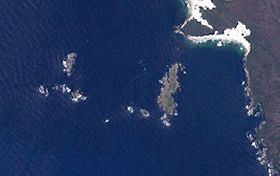
Mutton Bird Island is an irregularly shaped unpopulated island located close to the south-western coast of Tasmania, Australia. Situated some 2 kilometres (1.2 mi) south of where the mouth of Port Davey meets the Southern Ocean, the 44-hectare (110-acre) is the largest of the eight islands that comprise the Mutton Bird Islands Group. The Mutton Bird Island is part of the Southwest National Park and the Tasmanian Wilderness World Heritage Site.
Contents
- Mutton bird island rock jumping
- Map of Mutton Bird Island Tasmania Australia
- Mutton bird island coffs harbour
- Fauna
- References
Map of Mutton Bird Island, Tasmania, Australia
The highest point of Mutton Bird Island is 40 metres (130 ft) above sea level.
Mutton bird island coffs harbour
Fauna
The island is part of the Port Davey Islands Important Bird Area, so identified by BirdLife International because of its importance for breeding seabirds. Recorded breeding seabird and wader species are the little penguin (3,000 pairs), short-tailed shearwater, (530,000 pairs), fairy prion (2,500 pairs), Pacific gull, silver gull and sooty oystercatcher. Reptiles present are the metallic skink and Tasmanian tree skink.