
Country Turkey Elevation 1,163 m (3,780 ft) Licence plate 50 Area code 0384 | District Ürgüp Time zone EET (UTC+2) Postal code 50420 Province Nevşehir Province | |
 | ||
Mustafapa a nev ehir u rgu p turkey
Mustafapaşa is a belde (town) in Nevşehir Province, Turkey.
Contents
- Mustafapa a nev ehir u rgu p turkey
- Map of MustafapaC59Fa 50400 MustafapaC59Fa KC3B6yC3BC2FC39CrgC3BCp2FNevC59Fehir Turkey
- Geography
- History
- Economy
- References
Map of Mustafapa%C5%9Fa, 50400 Mustafapa%C5%9Fa K%C3%B6y%C3%BC%2F%C3%9Crg%C3%BCp%2FNev%C5%9Fehir, Turkey
Geography
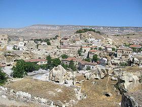
Mustafapaşa is a town in Ürgüp district of Nevşehir Province. At 38°35′N 34°56′E it is situated to the west of Gomeda valley. Its distance to Ürgüp is 5 kilometres (3.1 mi) and to Nevşehir is 27 kilometres (17 mi). The population of Mustafapaşa was 1550 as of 2011
History
Former name of Mustafapaşa during the Ottoman Empire era was Sinasos. It had a mixed population. Greeks and Karamanlides (Turkish speaking Christians) constituted the majority of the population and Muslim Turks constituted the rest. Although situated far from the seas Sinasiotes (Greeks from Sinasos) who temporarily migrated to İstanbul, were known to be the traders of seafood and especially caviare. The small town had many eloborate houses by the wealth from İstanbul. In 1924 however by the Population exchange between Greece and Turkey agreement, Greeks and Karamanlides left the town for Nea Sinasos a town in the northern part of the island of Euboea in Greece. They were replaced by Macedonian Muslims and Turks from Kastoria, a town in northern Greece. During the exchange years the town lost its former prosperity.
Economy
The town economy was used to depend on agriculture. But the town is a part of Capadocia, a touristic region of Turkey known for fairy chimneys and medieval rock carved churches. Now touristic hotels are being built around the town. A further expectation is thermal tourism