
Admin. region Tübingen Elevation 516 m (1,693 ft) Area 13.08 km² Postal code 89597 Dialling code 07393 | District Alb-Donau-Kreis Time zone CET/CEST (UTC+1/+2) Population 5,033 (31 Dec 2008) Local time Tuesday 4:42 PM Administrative region Tübingen | |
 | ||
Weather 12°C, Wind NW at 13 km/h, 60% Humidity | ||
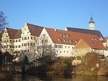
Munderkingen town
Munderkingen is the smallest town in the district of Alb-Donau in Baden-Württemberg in Germany. It is situated on the Danube, 9 km southwest of Ehingen, and 31 km southwest of Ulm.
Contents
- Munderkingen town
- Map of Munderkingen Germany
- Danube Bridge
- Old hospital
- Daughters and sons of the town
- References
Map of Munderkingen, Germany
Danube Bridge
The so-called "New Danube Bridge" 1893 was the first massive concrete arch bridge , which was built with an arch span of more than 50 m: Engineer Karl Leibbrand from Stuttgart was the builder, the work was carried out by the construction company Buck from Ehingen. The bridge was busted in World War II, on April 22, 1945, by retreating German engineering troops. Reconstruction began immediately after the war. In June 1948, the re-created Danube bridge was inaugurated by the occupying power of the French zone.
Old hospital
Built in 1889-90, the historicist building belongs to the townscape.