
Country United States Time zone Eastern (EST) (UTC-5) Elevation 225 m Zip code 40155 Population 1,043 (2013) | Incorporated 1952 FIPS code 21-54480 Area 150 ha Local time Tuesday 5:22 AM Area code 502 | |
 | ||
Weather 12°C, Wind N at 11 km/h, 70% Humidity | ||
Empty houses in muldraugh kentucky meade county
Muldraugh is a home rule-class city in Hardin and Meade counties in the U.S. state of Kentucky. It lies on U.S. 31W approximately halfway between Louisville and Elizabethtown. The city limits are completely encompassed by the Fort Knox army base. The population was 1,298 during the 2000 U.S. census and in 2012 the population was 1,053. The Meade Co. portion of Muldraugh is part of the Louisville–Jefferson Co. metropolitan statistical area, while the Hardin Co. portion is included in the Elizabethtown metropolitan area.
Contents
- Empty houses in muldraugh kentucky meade county
- Map of Muldraugh KY USA
- Geography
- Demographics
- In popular culture
- References
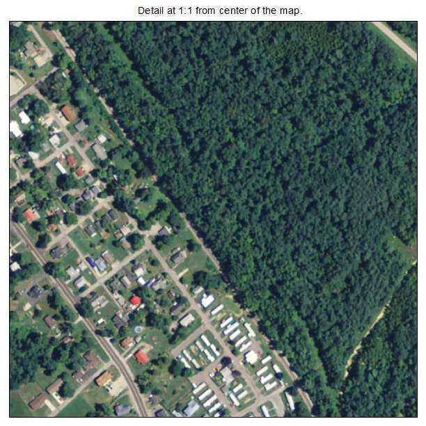
Map of Muldraugh, KY, USA
Geography
According to the United States Census Bureau, the city has a total area of 0.6 square miles (1.5 km²), all land. Muldraugh has the distinction as being the only one-sided town in the United States. With Ft. Knox territory on one side of US 31W, the town was forced to build on the parallel side.
Muldraugh is located just south of Muldraugh Hill at 37°56′13″N 85°59′29″W (37.936975, -85.991414). The road coming to the town from the north (now U.S. 31W and U.S. 60) is very steep, which is the source of the town's name: early on, reaching the area required a "mule-drawn" wagon.
Demographics
As of the census of 2000, there were 1,298 people, 519 households, and 319 families residing in the city. The population density was 2,264.6 people per square mile (879.2/km²). There were 635 housing units at an average density of 1,107.9 per square mile (430.1/km²). The racial makeup of the city was 82.36% White, 9.94% African American, 1.39% Native American, 1.00% Asian, 0.08% Pacific Islander, 2.16% from other races, and 3.08% from two or more races. Hispanics or Latinos of any race were 7.01% of the population.
There were 519 households out of which 34.7% had children under the age of 18 living with them, 38.2% were married couples living together, 17.0% had a female householder with no husband present, and 38.5% were non-families. 30.8% of all households were made up of individuals and 6.0% had someone living alone who was 65 years of age or older. The average household size was 2.50 and the average family size was 3.12.
The age distribution was 28.2% under the age of 18, 13.6% from 18 to 24, 34.7% from 25 to 44, 16.4% from 45 to 64, and 7.1% who were 65 years of age or older. The median age was 29 years. For every 100 females there were 104.4 males. For every 100 females age 18 and over, there were 107.6 males.
The median income for a household in the city was $29,712, and the median income for a family was $31,625. Males had a median income of $27,955 versus $20,450 for females. The per capita income for the city was $13,318. About 19.5% of families and 20.7% of the population were below the poverty line, including 27.6% of those under age 18 and 23.9% of those age 65 or over.
In popular culture
In the 1964 James Bond movie Goldfinger, a section of Main Street appears in the film. In the scene where Goldfinger's men are driving in Army trucks on their way to Fort Knox, they can be seen coming out of Harris Street turning onto Main St. The red brick house on Harris Street, the white cinder block building on the corner of Harris and Main, and the Used Cars sign in the background are still there today.
Muldraugh and environs are the focal point for the open-world survival-horror video game Project Zomboid.