
Type Valley Glacier Status Retreating | Terminus Ice-contact delta Length 17,703 m | |
 | ||
Similar McCarty Glacier, Riggs Glacier, Mount Muir, Margerie Glacier, Petermann Glacier | ||
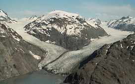
Muir Glacier is a glacier in Glacier Bay National Park and Preserve in the U.S. state of Alaska. It is currently about 0.7 km (0.43 mi) wide at the terminus. As recently as the mid-1980s the glacier was a tidewater glacier and calved icebergs from a wall of ice 60 m (200 feet) tall.
Contents
Map of Muir Glacier, Alaska 99826, USA
The glacier is named after Scottish-born naturalist John Muir, who traveled around the area and wrote about it, generating interest in the local environment and in its preservation. His first two visits were in 1879 (at age 41) and 1880. During the visits, he sent an account of his visits in installments to the San Francisco Bulletin. Later, he collected and edited these installments in a book, Travels in Alaska, published in 1915, the year after he died.
Retreat
Muir Glacier has undergone very rapid, well-documented retreat since its Little Ice Age maximum position at the mouth of Glacier Bay around 1780. Between 1941 and 2004 the glacier retreated more than twelve kilometers (seven miles) and thinned by over 800 meters (2625 feet). Ocean water has filled the valley replacing the ice.