
Country Nepal Time zone NPT (UTC+5:45) Zone Karnali Zone | Area 3,535 km² | |
 | ||
Region Mid-Western Development Region, Nepal | ||
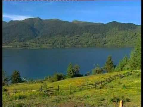
Field trip a beautiful place in rara lake at mugu district
Mugu District(Nepali: मुगु जिल्ला Listen , a part of Province No. 6, is one of the seventy-five districts of Nepal, a landlocked country of South Asia. The district, with Gamgadhi as its district headquarters, covers an area of 3,535 km² and had a population (2011) of 55,286. Mugu is known for being both the most remote district in Nepal, as well as the least developed.
Contents
- Field trip a beautiful place in rara lake at mugu district
- Map of Mugu Nepal
- Geography and Climate
- Tourism
- Village Development Committees VDCs
- References
Map of Mugu, Nepal
Geography and Climate
Mugu's geography is very rugged. The biggest lake in Nepal, Rara Lake—also known as Mahendra Daha—lies in Mugu District.
It is one of the biggest districts of Nepal. Pulu is one of the famous Village Development Committee (VDC) of Mugu district. There are many villages in this VDC namely Riusa, Mooh, Mangri, Serog, Dawra etc. Similarly, Seri Village Development Committee (VDC) is one of the famous VDC of the district. It is located to west of Rara VDC.
Tourism
The remote Mugu district is rich in natural resources. Nepal's largest Rara Lake lies in this district. Many domestic and international tourist come to visit the famous and beautiful Rara Lake. The lake is also known as the Mahendra Tal. The Lake liest at an elevation of 2,990 meters and covers about 10.8 km2 of area. The Rara National Park protects this beautiful Rara Lake.