
Prominence 195 m (640 ft) Elevation 936 m Mountain range Basque Mountains Parent range Basque Mountains | Translation Basque language | |
 | ||
Similar | ||
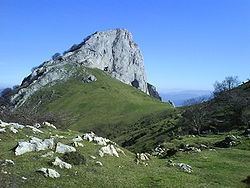
Mugarra is a peak of Biscay, Basque Country (Spain), 936 m high, belonging to the Aramotz massif.
Contents
Map of Mugarra, 48213, Biscay, Spain
The Aramotz massif is in the western limit of the Urkiola range. Mugarra continues the line of the Anboto, Alluitz, Aitz Txiki and Untxillaitz and is the eastern limit of the Aramotz massif.
Huge limestone rock where fossil rests of seashell can be found. The southern face forms a 300 m high cliff over the col of Mugarrekolanda. In this cliff have their nests the majority of the vulture couples of Urkiola (60 estimated). The northern face, facing Durango, is very steep but does not form a cliff, and it is covered by beeches and Cantabrian Holm Oaks.
The crest of Mugarra has many rock climbing ways, but climbing is not permitted to avoid disrupting of the vultures' habitat. This limestone crest is being consumed by a great quarry that causes irreparable damage to the mountain and is bordering the protected area.
Ascents
In Mañaria (181 m), a good path reaches the Mugarrekolanda (760 m) col. From the col an easy route leads to the summit from the west. It is possible from there to access the eastern part of the crest through the break of Atxurkulu (662 m). The ascent takes 2h.
.