
Country Thailand Time zone THA (UTC+7) Geocode 7001 Province Ratchaburi Province | Seat Na Mueang Postal code 70000 Area 430.3 km² | |
 | ||
Mueang Ratchaburi (Thai: เมืองราชบุรี, [mɯ̄a̯ŋ râːt.t͡ɕʰā.bū.rīː]) is the capital district (Amphoe Mueang) of Ratchaburi Province, western Thailand.
Contents
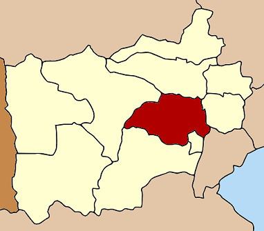
Map of Mueang Ratchaburi District, Ratchaburi, Thailand
History
The history of the area can be dated back to the Dvaravati town Khu Bua, located just a few kilometres south of the modern town of Ratchaburi. After being deserted for about 300 years, the town was reestablished near Wat Mahathat by King U-Thong of Ayutthaya. In 1817 the town centre was moved to the other bank of the Mae Klong river.
The district was one of the five original districts of Monthon Ratchaburi that were established in 1895 with Phraya Surinthararuchai (Thet Bunnag) as the first superintendent commissioner. At first the provincial administration was located in Photharam district, but was moved to tambon Na Mueang in 1898.
Geography
Neighboring districts are (from the north clockwise) Photharam and Damnoen Saduak of Ratchaburi Province, Bang Khonthi of Samut Songkhram Province, Wat Phleng, Pak Tho and Chom Bueng of Ratchaburi again.
The main river of the district is the Mae Klong.
Administration
The district is subdivided into 22 subdistricts (tambon), which are further subdivided into 187 villages (muban). The town (thesaban mueang) Ratchaburi covers the complete tambon Na Mueang. The township (thesaban tambon) Khao Ngu covers parts of tambon Chedi Hak and Ko Phlapphla. Lak Mueang covers the complete Khok Mo and Phong Sawai, and Huai Chinsi the complete Ang Thong. There are further 18 Tambon administrative organizations (TAO).