
Country Thailand Time zone THA (UTC+7) Geocode 7101 Province Kanchanaburi Province | Seat Pak Phraek Postal code 71000 Area 1,236 km² | |
 | ||
Mueang Kanchanaburi (Thai: เมืองกาญจนบุรี) is the capital district (Amphoe Mueang) of Kanchanaburi Province, central Thailand.
Contents
Map of Mueang Kanchanaburi District, Kanchanaburi, Thailand
History
Mueang Kanchanaburi was changed status to be the capital district (Amphoe Mueang) of Kanchanaburi province in 1913.
The old district office was located at Lak Mueang Road, Tambon Ban Nuea. It was moved to Sang Chuto Road, Tambon Pak Phraek on October 1, 1954.
Geography
Neighboring are (from west clockwise) Tanintharyi Division of Myanmar, Sai Yok, Si Sawat, Bo Phloi, Tha Muang, Dan Makham Tia of Kanchanaburi Province and Suan Phueng of Ratchaburi Province.
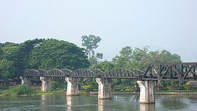
The Khwae Noi and Khwae Yai rivers are important water resources which join at the town Kanchanaburi to form the Mae Klong River.
Phu Nam Ron is a transnational cross-border point at the western end of the district. It is expected to gain in importance if the planned Dawei deepwater port project goes ahead, along with a highway and a railway line between Bangkok and that harbor.
Administration
The district is subdivided into 13 subdistricts (tambon), which are further subdivided into 99 villages (muban). The town (thesaban mueang) Kanchanaburi covers the tambon Ban Nuea, Ban Tai, and parts of Pak Phraek, Tha Makham, and also parts of the tambon Tha Lo of neighboring Tha Muang district. Additionally there are 3 townships (thesaban tambon) - Kaeng Sian, Nong Bua and Talat Ya each covering parts of the same-named tambon, and 11 Tambon administrative organizations (TAO).
Missing numbers belong to tambon which now form Dan Makham Tia