
States Palatinate forest Length 12 km | River system Rhine Basin area 15.24 km² | |
 | ||
Main source Hoher Stoppelkopf460 m (1,510 ft) Basin size 15.238 km (5.883 sq mi) Similar Rhine, Neustadt/Weinstrasse Railway, Hardenburg, Feller Bach, Haardt | ||
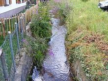
The Mußbach is a stream, nearly 12 miles long, in the eastern Palatinate Forest and in the Anterior Palatinate region in the south of German state of Rhineland-Palatinate. The former village of Mußbach (annexed by Neustadt an der Weinstrasse in 1969) was named after it.
Contents
Map of Mu%C3%9Fbach, Germany
CourseEdit
The two springs of the Mußbach rise a few hundred metres apart on the northeastern slope of the Hoher Stoppelkopf (567 metres) in the forest district of Wachenheim an der Weinstrasse. They converge after about 2 km. The stream, which usually carries very little water, enters the Silbertal ("Silver Valley") in the forest district of Deidesheim. After 6 km it reaches the Neustadt suburb of Gimmeldingen in the Benjental valley. Here, it is joined by an unnamed right tributary. The tributary is only 2 km long, but carries much more water. Its origin is the Loosenbrunnen springs on the north flank of the 533-metre-high Weinbiet on the eastern edge of the Palatinate Forest. Between 1952 and 1988, water from the spring was pumped up and used as drinking water in the local bar of Weinbiethaus.
The combined stream feeds a small reservoir serving tourism in the Gimmeldingen Valley and then reaches the vines landscape flanking the German Wine Route. Here, it flows through the Neustadt suburbs of Gimmeldigen en Mußbach. The confluence with the Rehbach, the northern tributary of the Speyerbach, is about 2 km southeast of this residential area.
NameEdit
In Middle High German, the stream, and the village named after it, were called Muosbach, meaning something like swampy brook, because natural streams meander and cause a high groundwater level.
MillsEdit
In the Middle Ages, the water of the stream was used to drive twelve mills. Their sites are now connected by the Mühlenwanderweg ("Mill Trail). Among these are, in downstream order:
EcologyEdit
In the 19th and first half of the 20th century, the stream was used as an open sewer. It is now partially restored, but also partially canalized.