
Topo map 260-C44 Parent range Southern Alps | Elevation 1,715 m | |
 | ||
Easiest route North Branch Borland Hut Similar Mount Anglem, Mount Tutoko, Roys Peak, Mitre Peak, The Remarkables | ||
Mount titiroa
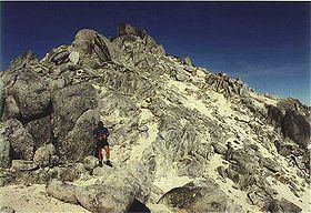
Mt Titiroa is a prominent landmark of the Te Anau Basin area of northern Southland on the eastern flank of Fiordland National Park. It is known for its white granite rock which gives its summit the appearance of lingering snow even throughout the summer months, and is clearly visible from Te Anau township.
Contents
- Mount titiroa
- Map of Titiroa Fiordland National Park 9691 New Zealand
- Fiordland nz mount titiroa
- References
Map of Titiroa, Fiordland National Park 9691, New Zealand
The mountain summit area is known as Geiger's Garden, and sports a number of oddly shaped boulders caused by exfoliation in the granties. These are popular with photographers and mountaineers.
In the 1990s,[1] the Havoc and Newsboy television series did a spoof episode on Mount Titiroa looking for a lost civilization, in which they sat astride a rock outcrop shaped like a giant stone turtle. Shortly after the TV broadcast the New Zealand Department of Conservation announced that no commercial guides would be allowed to take people into the Mount Titiroa area.