
Easiest route Hike Last eruption 1982 | Parent range Nasu Volcanic Zone Elevation 1,041 m | |
 | ||
Topo map Geographical Survey Institute (国土地理院, Kokudochiriin) 50000:1 樽前山, 25000:1 樽前山, 25000:1 風不死岳 Similar Mount Fuppushi, Mount Eniwa, Mount Usu, Hokkaido Koma‑ga‑take, Mount Monbetsu | ||
Mount tarumae
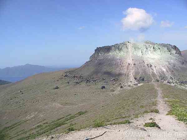
Mount Tarumae (樽前山, Tarumae-zan) is located in the Shikotsu-Toya National Park in Hokkaidō, Japan. It is located near both Tomakomai and Chitose towns and can be seen clearly from both. It is on the shores of Lake Shikotsu, a caldera lake. Tarumae is a 1,041 metre active andesitic stratovolcano, with a lava dome.
Contents
- Mount tarumae
- Map of Mount Tarumae Tarumae Tomakomai Hokkaido Prefecture 059 1265 Japan
- Eruptions
- Hokkaido Natural Monument
- References
Map of Mount Tarumae, Tarumae, Tomakomai, Hokkaido Prefecture 059-1265, Japan
Eruptions
The most recent eruption, in 1982, was a phreatic eruption. Previous major eruptions have occurred in 1667, 1739 (plinian eruption of VEI 5), and 1909. The 1667 and 1739 eruptions were responsible for its present shape. Other eruptions were in 1919–21, 1923, 1926, 1933, 1936, 1944, 1951, 1953–55, and 1978. Tarumae is an 'A' rank volcano — most likely to erupt in the relatively near future.
Hokkaido Natural Monument
Designated as a Hokkaido Natural Monument, it is popular as an easy climb for hikers who may start at the seventh station and then take an hour to reach the crater.
At the foot of Tarumae on the north-west side one can find an impressive moss-covered cavern (Koke-no-domon).