
 | ||
The Mount Tamalpais & Muir Woods Railway was a scenic tourist railway operating between Mill Valley and the east peak of Mount Tamalpais in Marin County, California, covering a distance of 8.19 miles (13.18 km), with a 2.5-mile (4.0 km) spur line to the Muir Woods. The railroad was incorporated in January 1896, and closed in the summer of 1930. Originally planned as a standard gauge electric trolley line, the railroad was powered by a succession of geared steam locomotives. Billed as the "Crookedest Railroad in the World," the line was renowned for its steep and serpentine route, winding through picturesque terrain to a mountaintop tavern providing first class hospitality and striking views of the San Francisco Bay Area. Despite its popularity, the railway met its demise following a fire in 1929, and dwindling ridership when the automobile could finally drive to Tamalpais' summit.
Contents
Mount Tamalpais
The peaks of Mount Tamalpais loom above redwood-shaded canyons and rugged grass-covered hills of Marin. Its highest point, east peak, is 2,571-feet. During the late 19th Century, Marin County was less regarded as a source of lumber, and a place of natural beauty and respite from the densely populated areas just south across the San Francisco Bay.
Mill Valley, located at the base of Mount Tamalpais, was first planned in the late 1880s and incorporated in 1900. The city was named for a sawmill built by John Reed, to cut lumber harvested from the surrounding area. Once the area was logged, the land was divided into parcels and sold as home sites, which at first were primarily Mill Valley, California vacation residences. The city was served by The Sausalito Land and Ferry Company and the North Pacific Coast Railroad. These provided access to Mill Valley, requiring a short ferry ride across the Bay from San Francisco to Sausalito, then a transfer to the railroad for another brief trip that terminated in Mill Valley. Mount Tamalpais lies only 12 miles (19 km) directly north of San Francisco and five miles (8 km) directly east of the Pacific Ocean.
Due to ease of access provided by the ferry and rail service, entrepreneurs realized the potential for transforming the sleepy hills north of San Francisco into a recreational destination. Sidney B. Cushing was one such individual. He had recently acquired the Blithedale Hotel summer resort just north of downtown Mill Valley in Corte Madera Canyon. The hills surrounding Mill Valley were rather steep—requiring a dependable means of transportation for them to become a vacation spot. Rail was the most logical means at the time, and Mount Tamalpais was the most attractive destination for such a line.
Formation and construction of the railroad
Louis L. Janes was the initial impetus behind creating a railroad at Mount Tamalpais. Janes was the resident director of the Tamalpais Land & Water Co. and first town clerk of Mill Valley. Sidney B. Cushing, president of the San Rafael Gas & Electric Co., was chosen as President of the corporation. It was initially named the Mill Valley and Mount Tamalpais Scenic Railway due to the fact the Muir Woods branch had not yet been planned. Funding came from several sources, provided to the corporation in exchange for stock in the company. One influential resident, A. E. Kent, gave the corporation right-of-way through his property in Corte Madera Canyon in exchange for $10,000 in stock. A. E. Kent and his son, William, were early Marin residents who foresaw the region's appeal to visitors from the Bay Area and beyond. William Kent was a Progressive Republican Congressman representing California from 1911–1917. Considering his family's financial interests in the railway, it is interesting to note that Kent spearheaded the movement to form the Muir Woods National Monument, a popular destination on the line.
Construction began on February 5, 1896. Originating at the North Pacific Coast Railroad depot in Mill Valley, the line was planned to ascend the surrounding hills to the summit of Mount Tamalpais, then over the top of the peak and down to Bolinas Beach. The pristine beach was difficult to access, and residents supported the line's planned arrival. This remained only a plan, as did the initial proposal to make the line an electric trolley route. A wagon road was constructed to Willow Camp (Stinson Beach) in 1902 and electric power never supplanted the geared steam locomotives used to construct the line. Supplies and laborers arrived in Mill Valley and began work by February 1896. Over 200 men, an international mix of laborers, graded the route and laid rails. Many left their jobs in protest over poor pay and expensive board—$1.75 a day for 10 hours of work followed by a night at an obligatory boarding house costing $5.25 a week. Despite these labor concerns and some local enmity from residents who opposed noisy locomotives running adjacent to their property, construction ensued. Within six months, the railroad construction was completed at a cost of $55,000; equipment cost an additional $80,000. The last spike was driven on August 18, 1896, with the first passenger train operating just four days later.
Route
The railroad's tracks originated from a depot located at 87 Throckmorton Avenue, at an elevation of approximately 70 feet (21 m). This building took several forms through the years, significantly more grandiose and Victorian than the current mission style depot occupied by a bookstore and cafe. Trains headed north through town, passing a water tank and shed at Lovell Avenue, and an engine house and shops on Corte Madera Avenue at Alcatraz Place. From the depot to King Street, the grade paralleled the Arroyo Corte Madera del Presidio stream that twists through Mill Valley between Blithedale and Corte Madera Avenues. Along the stream, the tracks continued north past the Blithedale Hotel until reaching Milepost One, at an elevation of 300 feet (91 m), approximately where Shady Lane crosses the stream today. At Lee Street the tracks passed a small station and water tank before continuing another 3/4 of a mile to Horse Shoe Curve, where the tracks crossed the stream one final time and headed southwest to Milepost Two. A siding was once located at Milepost Two, at an elevation of 400 feet (120 m). Continuing to head southwest, the tracks curved almost a dozen more times before reaching Milepost Three.
At Milepost Three, the route reached an elevation of 700 feet (210 m). Fern Canyon Drive currently follows this section of the old roadbed, including a tight curve at Summit Avenue, followed by numerous curves until reaching Milepost Four, lying just beyond a large home currently located at the end of Fern Canyon Road. From Milepost Four, the roadbed loops around the home and becomes a fire road available to hikers who, from this point, can follow the roadbed to its terminus at the peak.
Mesa Junction was just beyond Milepost Four at an elevation of 1,000 feet (300 m), the starting point of the "Double Bow Knot" curve where the track paralleled itself four times to quickly gain elevation. Within this curve, the track passed another small depot, siding and water tank at a stop named Mesa Station. A branch from mainline was added at Mesa Junction and headed southwest for Muir Woods, known as Redwood Canyon when it opened in 1907.
Just west of the Double Bow Knot, the tracks reached an elevation of 1,350 feet (410 m) at Milepost Five. Heisler locomotive No. 2 wrecked about 1/4 of a mile before Milepost Five on August 22, 1900, killing the engineer, Ernest Thomas. Grease deposits on the rail caused the locomotive to jump the rails and topple down the slope on the south side of the tracks, damaging the locomotive and releasing steam that fatally scalded Ernest Thomas.
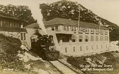
From this point, the tracks then headed west past another water tank, reaching Milepost Six at an elevation of 1,730 feet (530 m), where Boot Jack Siding was located. A half mile from Boot Jack the tracks finished their westward climb at the West Point Inn. In a tight 252° turn, they curved around the Inn and pointed east for another half mile to Milepost Seven at an elevation of 2,060 feet (630 m). Milepost Eight was further east up the mountain at an elevation of 2,350 feet (720 m). From here, the tracks wound around a broad curve for just less than a 1/4 of a mile to the railroad's final destination, Tamalpais Tavern, at an elevation of 2,436 feet (742 m).
Curvature
The railroad ascended a particularly steep grade from its starting point at the North Pacific Coast depot in Mill Valley – at an elevation of approximately 70 feet (21 m) – to its destination at a tavern just below the summit of Mount Tamalpais – at an elevation of 2,436 feet (742 m). In order to follow a grade that steam locomotives could ascend, the track had to maintain a reasonable vertical climb. The entire line's average grade was 5%, comprising maximum grades of 7% at some points on the line. As the crow flies, the peak of Mount Tamalpais is only a few miles from Mill Valley. However, a direct approach presented an impracticably steep ascent for the railroad. Thus, it meandered 8.19 miles (13.18 km) up the mountain, cutting its way back and forth across the terrain. According to an article entitled "Geared Locomotives on the Mount Tamalpais Railway" from the July 16, 1898 edition of Scientific American, the mainline had only 3.282 miles (5.282 km) of straight track, with the remainder composed of the following 266 curves:
Gravity Cars
The railroad became famous for its gravity cars, four-wheel coasters that took advantage of the steep, relentless grade, were first introduced in 1902. Gravity cars had an operator known as a gravityman who sat in the front right seat (on most cars) and operated two brake levers that pressed heavy duty brake shoes against the car's wheels. Gravitymen had strict orders to obey a 12 mile-per-hour speed limit as they glided down Mt. Tamalpais to either Muir Woods or into Mill Valley. "Gravities" ran at scheduled times, like all trains on the line, essential to safe operation on a single track railroad. Gravity cars were towed back to the summit by the steam engines, where they were stored in the yard for the next run.
Today
On May 3, 2009, a small museum opened in the former East Peak yard of the Mt. Tamalpais and Muir Woods Railway. The Gravity Car Barn shelters a recreated gravity car that rolls from the barn on 84-feet of rail. Volunteer Friends of Mt Tam docents staff the museum on weekends. Displays and a short documentary illustrate the railroad's story.