
Number of households 4,316 | Area 4.144 km² | |
 | ||
Restaurants Coquine, Sapphire Hotel, Cheese Bar, and cafe, Fern Kitchen | ||
Mount Tabor is the name of a volcanic cinder cone, the city park on the volcano, and the neighborhood of Southeast Portland that surrounds it, all in the U.S. state of Oregon. The name refers to Mount Tabor, Israel. It was named by Plympton Kelly, son of Oregon City pioneer resident Clinton Kelly.
Contents
Map of Mt. Tabor, Portland, OR, USA
Neighborhood
The Mount Tabor neighborhood lies between SE 49th Ave. (SE 50th Ave. south of SE Hawthorne Blvd.) on the west and SE 76th Ave. on the east, and between E Burnside St. on the north and SE Division St. on the south. It is bordered by Sunnyside and Richmond on the west, North Tabor on the north and west, Montavilla on the north and east, and South Tabor on the south.
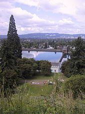
Mount Tabor Park is the neighborhood's principal feature. The campus of Warner Pacific College (affiliated with the Church of God (Anderson)) is located just south of the park. The neighborhood also marks the eastern end of the Hawthorne District. The campus of Western Seminary is located on the western slope, overlooking downtown Portland.
Before becoming part of Portland in 1905, Mount Tabor was a rural farming community dating back to the 1850s. It became a city-recognized neighborhood (encompassing a far smaller area than its historical boundaries) in 1974.