
Easiest route Mat-i Trail Prominence 2,248 m | Age of rock unknown Elevation 2,248 m Province Misamis Oriental | |
 | ||
Parent range Central Mindanao Cordillera Similar Mount Balatukan, Mount Kalatungan, Mount Dulang‑dulang, Mount Kitanglad, Paco | ||
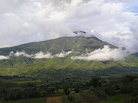
Mount Sumagaya is a mountain on the northern section of Mindanao in the Philippines. It is under the jurisdictional territory of the municipality of Claveria. It stands at a height of about 2,248 metres (7,375 ft).
Map of Mount Sumagaya, Claveria, Misamis Oriental, Philippines
It is part of the Central Mindanao Cordillera that stretches from Camiguin in the north to Sarangani in the south. The mountain rose to prominence during the crash of Cebu Pacific Flight 387 on its slopes in 1998, one of the deadliest aviation incidents in the Philippines.
References
Mount Sumagaya Wikipedia(Text) CC BY-SA