
Elevation 723 m | ||
 | ||
Similar Mount Prevost, Maple Mountain, Mount Tzouhalem | ||
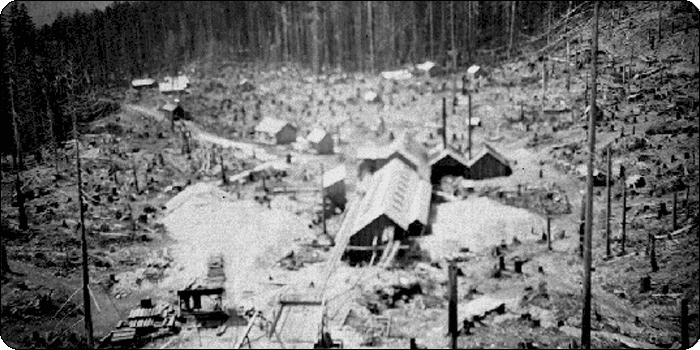
Mount sicker copper mine
Mount Sicker is a small mountain on Vancouver Island, British Columbia, Canada. It is near Crofton, Chemainus and Duncan.
Contents
- Mount sicker copper mine
- Map of Mount Sicker North Cowichan BC Canada
- Mining historyEdit
- LocationEdit
- UFO mysteryEdit
- Weather Radar StationEdit
- References
Map of Mount Sicker, North Cowichan, BC, Canada
Mining historyEdit
In the autumn of 1895, three American prospectors—F.L. Sullivan, T. McKay and Henry Buzzard—discovered traces of copper, gold and silver on Mount Sicker and staked their claims. The following spring, they began prospecting and digging a shaft until August, when a forest fire devastated the western face of Mount Sicker. The prospectors fled the site, and their cabin and gear were destroyed in the fire.
The fire was, however, a mixed blessing. When Harry Smith, their new partner, returned in the spring of 1897, the burned area revealed a 30-foot-wide (9.1 m) outcropping of copper at the mountain's 1,400-foot level (430 m). The new strike was named Lenora, after Smith's daughter.
When news of the discovery became public, a staking rush ensued and within weeks the entire mountain, base to summit, was staked.
By 1900, the townsite of Lenora was established and lots were sold -- $75 for corner lots and $50 for inside lots, with 1/3 payable in cash and the remainder payable in three and six months.
Throughout the first decade of the 1900s, Mount Sicker was the source of a number of mines—including the Lenora nearest the base of the mountain, the Tyee further uphill and the Richard III still further up the mountain—that would extract copper and send it to the Crofton smelter before being shipped across the world. The two main mines were the Lenora and the Tyee. One mine used an aerial tramway to ship the ore over the mountain to Stratford's Crossing on the E and N Railway. The other mine was served by the Leonora and Mt. Sicker Railway to Crofton. When the smelter closed in 1908, the mountain lost its importance to the economy.
The Lenora mine operated between 1898 and 1903 (when it became embroiled in litigation) and in 1907. The Tyee mine was worked intermittently between 1901 and 1909, while the Richard III mine operated between 1903 and 1907. During this time, the three mines reportedly produced 1,107 kilograms of gold, 22,955 kilograms of silver and 9,180 tonnes of copper from 229,000 tonnes of ore extracted largely by hand. The sites have been operated intermittently since 1909.
Many houses from the town of Mount Sicker were salvaged and moved to other communities in the Cowichan Valley, but some remained as a ghost town until weather, vandalism, and finally logging erased almost all traces. Mining activity has continued on a sporadic basis; in the 1970s a company was using a leaching process to recover minerals from the tailing piles. There's been core sample drilling around the mine area since then, so mining may return.
LocationEdit
Mount Sicker can be reached from Mount Prevost Road off Somenos Road or from Mt. Sicker Road off Westholme Road. The roads on Mount Sicker are unpaved, unmaintained and not sign-posted, and there may be active logging, so visitors should use common sense and caution. There are good views of the Gulf Islands and Chemainus River valley from the mountain.
UFO mysteryEdit
Mount Sicker may contain the answer to a local UFO mystery. In late November 1980, Granger Taylor, an unconventional genius and UFO fanatic who had built a small saucer about 15 feet wide on his parent's junkyard property, left his family a note saying he was going to travel on an "alien ship" for "a 42 month interstellar voyage" and he and his pickup truck were never seen again. Many years later, local newspapers reported that a logger on Mount Sicker spotted a crater in the ground and metal debris embedded in a tree. It is believed that Granger was carrying explosives in his truck at the time of his disappearance. RCMP reported that the debris contained a VIN number matching Granger's truck and that it was an apparent suicide.
Weather Radar StationEdit
The south face of Mt. Sicker has a doppler radar installation. This station populates the Environment Canada Mt. Sicker Radar Visibility Map. Access to the station is gated, under video surveillance, and fenced. In addition to the main radar dome, there are multiple transmitters that relay data across the Straight of Georgia and to Victoria.